HOW TO GET THERE: can be reached from Ugovizza via the road that heads to the Val Uqua and then via the track of the CAI 507 trail.

HOW TO GET THERE: from Dogna travel along the paved road of the homonymous valley and after 18 km you will reach Sella di Sompdogna. After a 10-minute walk along the track, you will reach the mountain hut. From Valbruna: Take the road that leads to the Val Saisera, until you reach the clearing of the Saisera alpine pasture. From here, continue on foot along the forest road which then becomes a mule track (sign- posted CAI 611) and after an hours’ walk and 400 vertical metres in a forest flourishing with beech, silver fir and Norway spruce trees, you will reach the mountain hut.
HOW TO GET THERE: from Camporosso via the Monte Lussari cable cars (for timetable information, call the Tarvisio Infopoint on +39 0428 2135) that takes 15 minutes. From Valbruna: Take the road that leads to the Val Saisera, until you reach the start of the CAI 615 trail and then continue on the CAI 616 and forest road (2 hours). From Camporosso: Along the CAI 613 “del Pellegrino” trail (approximately a 2 hours’ walk). The mountain hut is part of a small group of buildings located around the Sanctuary of Mariano Lussari. Services Luggage transportation, guided hikes.
HOW TO GET THERE: from Camporosso: Via the Monte Lussari cable cars (for timetable information, call the Tarvisio Infopoint on +39 0428 2135) that takes 15 minutes. From Valbruna: Take the road that leads to the Val Saisera, until you reach the start of the CAI 615 trail and then continue on the CAI 616 and forest road (2 hours). From Camporosso: Along the CAI 613 “del Pellegrino” trail (approximately a 2 hours’ walk). The mountain hut is part of a small group of buildings located around the Sanctuary of Mariano Lussari. Luggage transportation, guided hikes.

HOW TO GET THERE: the mountain hut is located near to the spring from which the Piave River flows. This spring is a place that is sacred for the nation and in 2015, the Flame of Peace was affixed here in the presence of the heirs of the Habsburg House. Arriving from Cima Sappada: Take the Val Sésis SP 22 by-road (approx. 8.5 km, 25 minutes by car), and pass by the Piani del Cristo Mountain Hut, Pian delle Bombarde and Sésis Barns until you reach the mountain hut. Arriving from Pian delle Bombarde (1457 m altitde, 1.5-1.75 hours, Tourist trail): head north along the nature trail to Passo del Roccolo (1815 m), then turn right onto Trail 136. You will reach the mountain hut shortly thereafter. Arriving from Val Visdende-Costa d’Antola (1332 m, 2-2.25 hours, Tourist trail): Take the cart track and at the second fork, head for Giau on the red cart track and Trail 133 up to Passo del Roccolo (1815 m). Turn left onto Trail 136 and you will reach the mountain hut shortly thereafter. Arriving from Val Visdende-Costa d’Antola (1332 m, 1.75-2 hours, Tourist trail): Take the cart track (Trail 136) towards Piè della Costa and after the second fork in the road, turn right towards Casera di Sésis and Passo del Roccolo (1815 m). Conti- nue along Trail 136 until you reach the mountain hut.
HOW TO GET THERE: take Trail No. 132 (2-3 hours, Easy hiking trail) from Cima Sappada or take Trail No. 137 (2 hours, Easy hiking trail) from Val Visdende. Alternatively, you can travel along the road in an off-road vehicle from Cima Sappada until you reach the Springs of the Piave River and then take Trail No. 132 (1 hour, Easy hiking trail).
HOW TO GET THERE: by car, motorbike or bike, take the road that leads from Forni Avoltri to Collina and then to Plan Val di Bos, where the mountain hut is situated. On foot: Walk along the CAI 143 trail from the Marinelli Mountain Hut, and the CAI 144 trail from the Lambertenghi Mountain Hut. Camping area, guided hikes. Wi-Fi service
HOW TO GET THERE: from the Forni Avoltri direction: take the CAI 143-signposted dirt road from the Tolazzi Mountain Hut, and you will reach the Mari- nelli Mountain Hut in 2 hours. From the Paluzza direction: take the SS52-bis road towards the Plöcken Pass and take the dirt road on the left just before you reach the bor- der. Follow the CAI 146 signposts for the Tra- versata Carnica. The road immediately beco- mes a trail and you will reach the mountain hut in 2.5 hours. Alternative route: from the Plöcken Pass on the CAI 146/148 trails. This is the difficult La Scaletta pass where equip- ment is required and the Monumenz. You will arrive in 3 hours after passing the Plotta Lake.

HOW TO GET THERE: the mountain hut is located in the village of Sella Nevea. It can be reached from Chiusa- forte via the SP76 Val Raccolana B-road in approximately 15 km or from Tarvisio, via the SS54 and the SP76 road, which pass after 20 km through Cave del Predil.

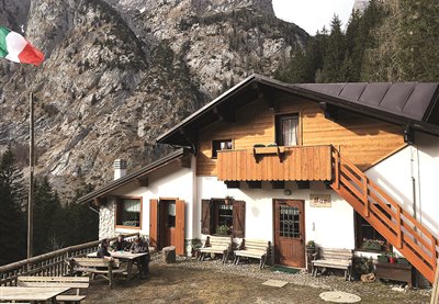
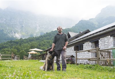
HOW TO GET THERE: the mountain hut is located in the village of Valbruna, and can be reached from the Ugo- vizza-Valbruna exit of the A23 motorway. Continue left towards Valbruna for 1.5 km and, after the first few houses, you will arrive at the Casa Alpina.

HOW TO GET THERE: from Sauris di Sotto: leave your car near the Town Hall, then continue northwards along the road. Shortly afterwards, the paved road becomes a dirt road and after climbing and descending a number of times along an uneven path, the mountain hut can be reached in 45 minutes. From Lateis: once in the village, leave your car at the end of the paved road and continue along the CAI 220 trail.

HOW TO GET THERE: continue for 6 km from Paularo, until you reach Casera Ramaz and park your car. Take the CAI 454 trail and once you have pas- sed Casera Lodin, you will reach the Moun- tain Hut in 2 hours.
The Glazzat Bassa Alpine pastures are used at the beginning and end of the grazing period. Here thrive such species as the Alpine clover, the bearded bellflower, the wild geranium and various ferns. The Glazzat Alta pastures and hut structures (1,348 m), with its additional rural tourism activities, are part of this facilities.
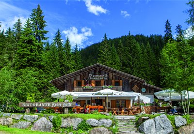
The structure rises near the Pramollo pass and between June and July its fields are home to the blooming of the magnificent Wulfenia carinthiaca, a protected botanical species discovered in 1779 and only present in very few areas (Albania and Montenegro, the Himalayas and Asia Minor). This plant is protected due to its rarity and a special celebration is organized here during its flowering period.
The malga is located within the Julian Prealps Park and a didactic itinerary has been created next to the structure. In Resian "Coot" means corner, and indeed this malga rises on the corner of the valley. The "Sentiero per tutti" (lit. “Trail for all”), dedicated to excursions for disabled visually impaired individuals, can be found in the Pian dei Ciclamini area.
The malga was recently restructured, while retaining its original architectonic characteristics. Nearby, you can visit Lake Malins and observe the many newts that inhabit its waters. This picturesque Alpine landscape is particularly suggestive, due to a gorgeous view of the Pesarine Dolomites. By proceeding left from the shelter, you can reach malga Vinadia Grande and then descend towards the Pesarine Valley.
Lying at a comparably low altitude, its pastures are grazed between mid-May and mid-October. The grassy saddle of Navas (1,025 m) overlooks the Degano valley, northward, and is dominated by the calcareous massifs of the Monti di Volaia and by the Monte Coglians to the north, while you can admire the plateau of Lauco and its hamlets to the south-east.
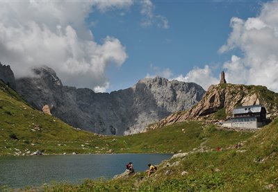
The Carnic Alps hold a wealth of surprises in store for active explorers. One of them is Lake Wolayersee on the Carinthian side of the Carnic main ridge, near Plöcken Pass. On sunny days, the peaks of Hohe Warte, Seewarte and Seekopf are reflected in the glittering, turquoise-coloured waters of the lake. The lake is a geological peculiarity, as it is not fed by a spring, but consists of rain and meltwater that collects in a doline dating back to the Ice Age. Normally, this water would seep away through the rock, but here, it doesn't - much to the delight of modern-day hikers, who are able to enjoy the beautiful views across this idyllic mountain lake. A leisurely "Jause" with regional delicacies on the terrace of Wolayersee hut, gazing across the waters of the lake and the surrounding mountains, is a perfect way to while away the hours. But this popular day trip destination has even more to offer: the hut has several rooms and a dormitory with mattresses and is an important base for long-distance hikers on the Karnischer Höhenweg trail as well as passionate climbers, with two via ferratas leading up Hohe Warte. Hikers who prefer a less hair-raising approach can find out plenty of fascinating facts about the formation of this imposing mountain panorama on the geotrail. Wolayersee hut is a two and a half hour walk from Hubertuskapelle chapel in Wolayertal valley and a three-hour walk from the Untere Valentinalm pasture on Plöcken Pass.
The structure was built near the peak of the homonymous mountain, in a location characterized by its suggestive beauty. This splendid panoramic position makes it a spectacular observation point looking onto nearby Alpine peaks such as the Çuc dal Bôr, Mount Cavallo, the Montasio Jôf and the Mangart. The area is inhabited by deer, roe deer and corncrakes.
Zollnersee hut is operated by the Austrian Alpine Association and lies nestled against the beautiful pastures right next to the Italian border, between Plöcken Pass and Nassfeld. It is a fixture for long-distance hikers along the Karnischer Höhenweg trail as well as for day trippers staying in the region. The Zollnersee region is also highly recommended for families as it may be reached on foot, by mountain bike or by car. Its name derives from nearby Lake Zollnersee, accessible directly from the hut via gentle walking paths that lead across a moor. In 2015, the region with its geotrails was awarded the UNESCO Global Geopark logo. Lake Zollnersee itself is the perfect destination for travelling through time, back to the Palaeozoic age, and a real-life geology lesson. Zollnersee hut itself received an award in 2018, when it became the first Slow Food Travel Hut along the main ridge of the Alps, serving only regionally sourced farm products - quality you can taste! For a full-day programme, the locals recommend a detour to Rifugio Fabiani via Zollnertörl. The nearest summits of the Kleiner Trieb, the Hoher Trieb and the Findenig offer one-of-a-kind views of the mountain panorama of the Carnic Alps. If you would like to spend the night in Zollnersee hut, make camp in the dormitory with mattresses or in one of the two double rooms. After a wonderful mountain breakfast, pay a visit to Rosser hut, where Gailtaler Almkäse and other dairy products are made from scratch throughout the summer. Yet another must-see is the Chapel of Peace, built in memory of the turmoil of World War I - an architectural gem that fits in beautifully with the surrounding landscape.
The main door of this malga features carvings and engraved initials that reveal the artistic skills and passions of the many malghesi and shepherds who lived here over the course of time. The malga is open in the intermediate grazing period, while its activities move to malga Ielma di Sotto during the initial and final pasturing phases. Similarly to a few other shelters in the region, the traditional boiler for milk processing, known as the “musse”, has been conserved in Upper Ielma. Above the basin where the malga is located, the slopes of the San Pietro Hill are peppered with larches, spruce trees and a few specimens of beech trees, while many raspberries can be found in the undergrowth. This malga offers a spectacular view of the Pesarine Dolomites. By crossing the pass from Upper Ielma you can descend towards the Pieltinis shelter and then to the Sauris basin (CAI trail n. 218).
Similarly to a few other shelters in the region, the traditional boiler for milk processing, known as the “musse”, has been conserved in Lower Ielma. The first documents referring to this malga date back to as early as the thirteenth century. Above the basin where the malga is located, the slopes of the San Pietro Hill are peppered with larches, spruce trees and a few specimens of beech trees, while many raspberries can be found in the undergrowth. The malga is open during the first and last weeks of pasture, while activities move to malga Ielma di Sotto during the intermediate period. By proceeding leftwards from the crossroads - located shortly after the shelter - visitors can reach San Giacomo; by proceeding straight ahead from here, you can climb a few short hairpin bends towards the nearby Ielma di Sopra shelter and then towards malga Pieltinis.
Above the pastures of malga Meleit is the peak of Mount Dauda (1.765 m a.s.l.), offering a majestic view on the valleys below. In order to reach the peak, you should proceed eastwards and, when the path starts its descent, take the trail on the right which traverses the ruins of the Chiâs di Sopra shelter and leads to the southern ridge of the mountain. From here, follow the crest leftwards to reach the peak. From the shelter, visitors can also reach Villa Santina or Zuglio. To get to the former, descend rightwards to reach Val di Lauco, Vinaio and Lauco; to reach the latter, proceed to the left until you get to malga Dauda, the Fielis hamlet and finally Zuglio.
The abundance of green alders makes this malga an ideal environment for goat grazing. A particularly interesting plant one may encounter in this area is the Rhodothamnus chamaecistus. By walking downwards from the Valuta shelter you will leave the detour towards Monteriù to your left and lose altitude until you encounter the confluence between the torrents Novarza and Pieltinis; from here, you can climb back upwards towards the path that connects Lateis di Sauris to the malghe of the district.
On the first Sunday of August, mass is held for the Alpine troops in the chapel next to the Malga, in memory of the discovery of the Redeemer during the Great War: the chapel was built by Alpine troops specifically to protect this finding. The pasture is called Pizzul because the Malga was split in two parts and this word means “Small” in the Friuli dialect. From the shelter, visitors can climb towards the Pizzul pass and descend from there directly to Cason di Lanza (CAI trails n. 441, 442, 442A). If on the other hand they choose to follow the dirt road, this will lead them to the nearby malga Paluchian (CAI n. 441B). The first historical document to reference the area indicates that animal grazing took place in malga Pizzul as early as the summer of 1295.
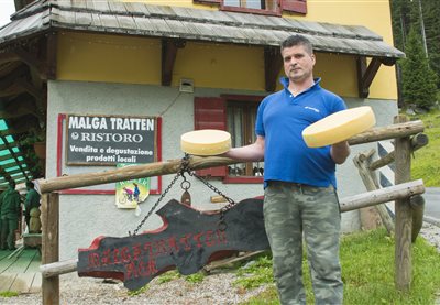
The dairy hut, also known as "Paronuzzi" is the most important alpine farm of the Cansiglio-Cavallo hogback. Located near the Piancavallo tourist resort, this farm is the only old high-altitude production units on the plateau that is still in operation.
This pasture plays an important role for the grazing sector due to its majestic nature. Near the malga is the usually dry riverbed of a branch of the Rio Losa, where you can observe alpenroses, hairy alpenroses, specimens of erica carnea or spring gentian. By proceeding on CAI trail n. 220 you can reach malga Forchia and descend towards Ovaro; above the Forchia shelter, visitors will find the start of the path leading up Col Gentile to an altitude of 2.075 m a.s.l. (CAI trail n. 235).
The pasturing area - which consists of various environments, the grazing space, the buildings, the wood and the waterholes - is frequented by numerous bird species, such as black redstarts and yellowhammers that find ideal feeding and nesting conditions in this area. However, the large amount of small birds also attracts their most deadly predator, the Eurasian sparrowhawk. By proceeding beyond the shelter, you will reach malga Pieltinis and the homonymous mountain (CAI trail n. 206).

The Val Cimoliana continues and, through the unpaved road and some crossings of the stream, you can reach the Pordenone refuge and subsequently the Meluzzo Hut. The Pordenone refuge represents the point of support for climbing up to the Bell Tower of Val Montanaia, a 300 meter high dolomitic spire of spectacular and wild beauty. The splendid obelisk is included in the "Italian Wonder" project. From the casera you can continue on a track with natural ground in a beech forest and reach Malga Sponda Alta.
The entire mountain range extending between Mount Rivo to the West and the peak of the Tersadia to the East is located in a central and isolated position from the Carnic area. These peaks offer breathtaking 360° views: from the High Tauern to the North all the way to the Adriatic Sea to the South, from the Dolomites located to the West to the highest peaks of the Julian Alps to the East. This ridge was used as a defensive system in the front line area during the Great War. Immediately under the peak are noteworthy remains of fortifications, walkways, trenches, tunnels and barracks. The malga complex known as the “Valmedan-Cucco” is located on the southern side of Mount Tersadia; from here, we highly recommend the excursion towards the suggestive peak of Mount Tersadia, at an altitude of 1.959 m a.s.l. (CAI trail n. 409), and the descent to Treppo Carnico in the Pontaiba Valley. From malga Valmedan Alta, you can also reach the Cucco shelter (on CAI trail n. 409) and then climb towards the homonymous peak at an altitude of 1.804 m (CAI trail n. 408°).
The 360° degree view allows observers to admire the Adriatic Sea, Mount Lussari and the Grosslockner. The nearby Mount Tenchia is the location of the "witches plateau", shrouded in legends concerning secret meetings between local and Nordic witches. This local myth inspired the poem "In Carnia" by Giosuè Carducci. Outcrops of effusive volcanic rocks can be found in the small lakes of Zoufplan. Here, the local Civil Protection has built a building to house a weather radar and tools for detecting seismic movements. From the malga, you can climb to Mount Tenchia, to the Zoufplan lakes and to the panoramic Cimon di Crasulina; from here, you can follow CAI trail n. 154 along the entire Tarondon – Pezzacucco – Crostis ridge.
Also known as the "Schenewelde" farmhouse, the structure rises nearby the homonymous pass, in a small panoramic valley surrounded by an unspoiled natural environment. A particularly noteworthy landmark is the "Tiziana Weiss Naturalistic Trail", one of the first self-guided trails of the Region.
This entirely restructured shelter has retained its ancient architecture thanks to a meticulous recovery of the ancient stones that made up the original walls of the building. After returning to malga Ielma di Sotto, you can proceed leftwards towards the Jelma pass and descend towards the Pieltinis shelter and then to the Sauris basin (CAI trail n. 218).
This malga is located on the North-West flank of Col Gentile, and from the peak of this mountain you can enjoy a magnificent view of the green Losa, Navarza and Torondon mountain range, of the glacial valleys that cross its southern flank and of the Creta Forata on the background. By climbing northwards, visitors can reach the Malins and Festons malghe and descend towards Upper Sauris (CAI trail n. 204); if they choose to proceed southwards, CAI trail n. 206 will lead to the Pieltinis and Gerona malghe and then descend towards Lateis di Sauris.
CAI trail n. 402, which connects Pramosio to Malpasso, features the memorial plaque dedicated to Maria Plozner Mentil, killed while carrying supplies to the frontline. Her story and that of all Carnic Bearers was progressively forgotten up until 1997, when the former President of the Italian Republic Scalfaro awarded these historical figures with the Gold Medal for Military Valour. From the Pramosio Pass you can visit numerous First World War sites and structures such as tunnels, trenches and posts. Malga Pramosio is the location of the only medieval mining tunnel in the eastern Alps, still intact in its original state. By proceeding beyond the shelter on CAI trail n. 402, you can reach the Malpasso ricovero Morgante shelter, the shelter of the Manze and, at an even higher altitude, the Upper Pramosio shelter with the splendid Lake Avostanis, surmounted by one of the most beautiful cliffs in the eastern Alpine range.
The pastures of malga Pieltinis cover the entire East flank of the homonymous mountain and the valley line beneath the peak features one of the richest heath areas in the whole Carnic Alps range. In addition to Alpine rhubarb, the meadows next to the malga also feature Alpine Timothy-grass, dandelions and specimens of Campanula scheuchzeri. From the Pieltinis shelter visitors can climb rightwards, traverse the Ielma pass and descend towards the Ielma di Sopra and Ielma di Sotto malghe before reaching the Pesarine Valley (CAI trail nThe pastures of malga Pieltinis cover the entire East flank of the homonymous mountain and the valley line beneath the peak features one of the richest heath areas in the whole Carnic Alps range. In addition to Alpine rhubarb, the meadows next to the malga also feature Alpine Timothy-grass, dandelions and specimens of Campanula scheuchzeri. From the Pieltinis shelter visitors can climb rightwards, traverse the Ielma pass and descend towards the Ielma di Sopra and Ielma di Sotto malghe before reaching the Pesarine Valley (CAI trail n. 218); turn leftwards from the lodges to traverse the Pieltinis pass and descend towards the Vinadia Grande malghe (CAI trail n. 204).. 218); turn leftwards from the lodges to traverse the Pieltinis pass and descend towards the Vinadia Grande malghe (CAI trail n. 204).
The green alder shrubs near Malga Vinadia Grande are an ideal habitat for black grouses. Climbing northwards visitors can reach the Malins and Festons malghe and form there they can descend towards Upper Sauris (CAI trail n. 204); by proceeding southwards, you will reach the Pieltinis and Gerona malghe and descend towards Lateis di Sauris (CAI trail n. 206).
From Paularo, you can follow indications for the Cason di Lanza pass and, after passing the Lower Ramaz Shelter, reach the Lower Meledis pastures in less than one kilometre. The malga is open during the first and last weeks of pasture, while activities move to malga Meledis Alta during the intermediate period. By proceeding along the road, visitors can climb to the Lower Valbertat shelter and, by turning left from here, reach malga Valbertat Alta. From here, they can enter the Austrian territory on CAI trail n. 449 and proceed to malga Straniger.
The Montasio plateau, a place of extraordinary beauty, is the largest grazing area in the entire region. The following malghe are all located in this district: Cregnedul di sopra, Larice, Parte di Mezzo and Pecol, dedicated to cheese production and agro-tourism. The history of the area describes the birth of Montasio cheese at the start of the thirteenth century, thanks to the Benedictine monks from Moggio Udinese. From a naturalistic point of view, in this area visitors can encounter rooster combs, broom flowers, marmots, deer, chamois, roe deer and foxes. From the Plains of the Montasio, you can return to Sella Nevea and descend towards Tarvisio via the town of Cave del Predil with its charming lake. Starting from the Pecol shelter, you can also easily reach the Giacomo Di Brazzà Refuge (on CAI trail n. 622), a splendid balcony looking onto the Mount Canin range.
The structure is open during the intermediate pasturing period, while its managers carry out their initial and final pasturing period activities in malga Ramaz instead. The structure is located on the southern slopes of Mount Lodin, characterized by Silurian rocks of marine origin that contain many invertebrate fossils, such as those of cephalopods with their characteristic shells. Corals are also frequently found in this area. The shelter is located on the “Carnic Crossing” and “Carnia Trekking” trails. From the malga, visitors can climb to the Lodinut pass (CAI trail n. 457), and by proceeding leftwards from there (CAI trail n. 403) they can reach Lake Zollner See in the Austrian territory, easily get to the Pecol di Chiaula pass and descend to the Pietro Fabiani refuge (CAI trail n. 454), therefore completing a circle and reuniting near the Upper Lodin shelter with the path that led them up the mountain.
During the war, this shelter was the logistics centre of the valley and it still features the remains of military shelters, as well as a cave known as the “Company of the Brigands”. A small church was built near the malga to commemorate the fallen soldiers from the Gemona Battalion. The farmhouse is the result of restructuring operations on the shelter that had been abandoned during the early 1950s, when traditional grazing activities no longer took place here: its recovery further valorises one of the many historical sites of the valley. From here, you can enjoy views of the Jôf del Montasio and the Julian Alps range. From a naturalistic point of view, in this area you will find: wild orchids, roe deer, chamois, deer and lynxes. From the malga, you can climb towards Sella Sompdogna, reach the homonymous malga and, from there, proceed even further towards the Grego Brothers Refuge.
The malga is open during the first and last weeks of pasture, while activities move to malga Lodin Alta during the intermediate period. The Stua di Ramaz is located nearby, East of the Chiarsò torrent. The site takes its name from the large barrier (“stua”= enclosure) once built to facilitate the transportation of timber towards the valley. On July 15th 1944, while exploring the north-eastern Carnia mountains, German soldiers killed some shepherds in Malga Cason di Lanza and Malga Confin e Meledis. A memorial stone featuring the writing “peace to the fallen ones – aid to themselves” was erected in 1946 to commemorate the victims from Lanza and Cordin, and can be found on the path leading from Paularo to Cason di Lanza via the Ramaz Shelter. From the shelter, visitors can reach the Cason di Lanza pass and either proceed on the road towards Pontebba or follow CAI trail n. 454 towards the Fabiani Refuge.
In 1478, on Plan di Lanze, a violent battle took place between the Turks – who were trying to cross the pass – and Venetian troops flanked by Carnic militias. The Turks were defeated and pushed back, and the Carnia area was therefore saved from their dreaded raids. According to legend the name, Plan di Lanze, derives from the lances abandoned on the battlefield by the defeated Turks. A didactic rocky gym has been built at a distance of just approximately one hundred metres from the shelter. This site offers a magnificent view of Mount Zermula and of the Creta di Aip. The shelter is the ideal starting point for many excursions, including climbs towards Mount Zermula (2.143 m) (CAI trails n. 442 and 442A), or towards the Lomasti bivouac, via malga Val Dolce and the Aip Valley (CAI trails n. 439 and 440).
From the start of the Mount Croce Carnico Pass terrace, proceed leftwards along a dirt road (CAI trail n. 161) to reach the nearby malga Collinetta di Sotto in just a few minutes. Along the way, you will encounter various inscriptions marking the “Via Julia Augusta” that once connected Aquileia to Noricum through the Mount Croce Carnico Pass. The Austrian flank near the pass is the location of the first recoveries of Great War posts for the outdoor history Museum that develops all the way to the peaks of the Pal Piccolo (1.866 m), Freikofel (1.757 m) and Pal Grande (1.809 m). From here, you can proceed westwards on CAI trail n. 148, leading to the road towards malga Val di Collina, malga Collina Grande, malga Plotta, the Monumenz shelter and the Marinelli refuge.
Starting from this pasture, which offers a fascinating view of the Dolomite range, visitors can reach the trail climbing from Cima Sappada towards the Source of the River Piave and the “Pier Fortunato Calvi” Refuge. The southern flank of Mount Avanza, which dominates this pasture, features ancient copper and silver mines still containing the remains of pestles used for the crushing of minerals. This area of noteworthy historical value can be reached by following CAI trail n. 173, starting from the hairpin bend located 100 m to the East of the shelter and climbing steeply towards a crossroads where visitors should follow CAI trail n. 177 to the right.
The structure rises on the southern-east side of Mount Punta Bella. From this panoramic point you can enjoy a view on the Valle del But, on Val Lauco, on Val Tagliamento to Prealpi Carniche and Marano lagoon. Its position is strategic in the hiking and cycling scene.
The malga is open during the intermediate pasturing period, while its managers carry out their initial and final pasturing period activities in malga Meledis Bassa. Visitors can observe Austrian trenches from the Great War on the Puartis Valley Peak, slightly above the shelter. On July 15th 1944, while exploring the north-eastern Carnia mountains, German soldiers killed a few shepherds on the Lanza and Cordin malga. These victims are celebrated by a memorial stone featuring the words “peace for the fallen ones – aid to themselves”, located on the path leading from Paularo to Cason di Lanza via the Ramaz Shelter. From the shelter, you can reach the Upper Lodin malghe (on Cai trail n. 448B), or choose to turn right and cross the Malinfier brook, reach the Meledis pass and descend towards malga Straniger, in Austria.
On the asphalt road from Paularo, follow indications towards the Cason di Lanza Pass and turn right in the “Baita da Nelut” area onto a very steep forest path (CAI trail n. 442) that climbs towards the Zermula shelter. Along the path from Paularo to the malghe, approximately one kilometre after the “Maina della Schialute”, visitors will find indications for a short trail leading to the “Palm”, a prodigious secular white fir tree listed among the main natural monuments of the Friuli Venezia Giulia region. Trenches dating back to the Great War can still be found nearby the malga. Proceed on the road built during the First World War to reach the peak of the panoramic Mount Zermula (2.143 m).
This malga was rebuilt after being destroyed by an avalanche during the 1980s. From the Moraretto shelter, visitors can follow a road or CAI trail n. 143 to the Giovanni Marinelli Refuge (2.111 m), built in 1901, and then descend along CAI trail n. 148 towards the Mount Croce Carnico pass. The pastures extending between the shelter and the Marinelli Refuge are home to a large colony of marmots. The hamlet of Collina in the Forni Avoltri area is particularly important for the regional dairy sector, given that the first local dairy production cooperative was founded here in 1881: the building still stands here with its ancient sign.
Dirt roads may include fairly bumpy stretches, especially after unfavourable weather; in particular, the descent from the Corce saddle to the ruins of the Dolaces farmhouses. In the densely-growing brushwood shrubs lives a nice, peculiar animal: the dormouse, a small rodent of the Gliridae family with a bizarre tail which is longer than its body and moderately prehensile. This allows it to move acrobatically around bushes.
The structure is surrounded by an actual natural botanical garden, featuring great yellow gentian, wild gladiolus and carnations. The homonymous mountain appears as a grassy pyramid from which the viewer can observe the entire Friuli region. The top of the mountain houses the small Church of the Redeemer. Near the malga is the start of the downhill trail.
The panoramic view on the breathtaking naturalistic landscape you can enjoy from this malga covers the entire plain of the Friuli region and, on particularly clear days, the viewer’s gaze can travel all the way from the course of the Tagliamento River to the Adriatic Sea. Griffons are known to circle in the skies of this area, while the fields are inhabited by feral horses (Koniks).
The structure is located on a grazing saddle on the border of the Julian Prealps Natural Park, on the mid-southern flank of Mount Lavara. The shelter is surrounded by unspoiled nature, where walkers may encounter roe deer, chamois, ibex, marmots, eagles and many other animal species.
The Pancotto family has managed the malga, farm restaurant and didactic farm since 2011, offering children and kids the opportunity to spend a week discovering life in the pastures.
The Alpine farm is located inside a doline, a karstic depression called "fossa" in the local dialect. Under the new facilities the remains of the old buildings can still be discerned. The natural or man-made water pool is called "lama". The entire district is marked by these small hollows with impermeable bottoms where rain water and melting snow gather.
The Alpine farm is located in a small hollow at the feet of the Col Scarpat and also includes the pastures of the Bos and Busa Bravin farms, whose long abandoned facilities are no longer recognizable. The stony pastures characterize the farm, as does the juniper, a plant usually avoided by animals because of its stinging leaves. The location of these pastures offers a broad view over the whole Friulian Alps range.
The farmhouse is located in an old building which has retained all of its ancient charm, surrounded by hills and beech woods. The malga (mountain hut) is located in the southernmost part of the Cansiglio Forest, the second largest in Italy and one of the most important environmental resources of the entire region. The Patriarca trail passes in front of the malga.
This pasture is very rich both in terms of wildlife and from a naturalistic point of view, thanks to the presence of nettle, ferns, yarrow and mountain sage. The renovation of the buildings involved the historical recovery of the old shelter as a testimony of ancient life in the pastures.
Stop - I think I saw something move up there on the rock! Slow down your steps, lift the binoculars up to your eyes - and there it is. Not far from the trail leading up to Rudnig Alm pasture, a marmot has come out of its hiding place to sunbathe on the rocks. A wonderful sight for mountaineers! The chances of spotting a marmot are highest during the early hours or late morning, when the trails of the Carnic Alps are not yet busy. Head along the gravel path up to Rudnig Alm at dawn, where you can watch the beautiful colours of the sunrise while enjoying a proper mountain breakfast with home-made delicacies aplenty - Gailtaler Almkäse, fresh butter, "Schotten" cheese, curds and soft cheeses from the mountain dairy. Rudnig Alm pasture is located just below the Roßkofel and Troghöhe mountains. From the hut, climbers can get up the Roßkofel in approximately three and a half hours. The Rudnigsattel is a 45-minute hike away. The pasture makes an ideal starting point for hiking and climbing tours, and there is also the option of staying overnight. If you prefer to take it easy, explore the spacious pasture surrounding the hut and enjoy the fantastic panoramic views of Nassfeld Pass and Madritschen mountain and the nearby reservoir. And who knows, you might even spot another marmot on the way back!
Just follow the cheese! is the motto of the cheese-themed circular trail in the market town of Kirchbach. The trail is a comfortable day's walk across the border between Carinthia and Italy, leading from pasture to pasture. Display boards and sunny mountain huts invite you to take a rest in between. One of them is the Kleinkordin Alm pasture, easily accessible via a well-maintained gravel road. The starting point of the tour is Straniger Alm pasture, 3km from Kleinkordin Alm, whose huts are located at an altitude of 1,623m, just below the Hochwipfel summit. This authentic, agrarian pasture serves Gailtaler Almkäse (Protected Designation of Origin) as well as other delicacies, such as Gailtaler Almschotten, creamy yoghurt and a wonderfully tasty hard cheese, all made from the milk of the dairy cows that enjoy their summer break up in the mountains. Following some hearty mountain refreshments from the farm and dairy, visitors are well prepared to climb the Hochwipfel, the nearest summit, and the Schulterkofel, both offering beautiful views of the surrounding mountain panorama. The pasture is located along the Karnischer Höhenweg trail.
The pointed cone of the Findenigkogel (Monte Lodin) at the Italian border is visible from afar. As charismatic as the mountain itself is the gnarled wooden cross on the summit and the splendid views across the Carnic Alps. Hikers descending to the foot of the Findenigkogel or mountain bikers who explore the area of the former World War I front will pass the rustic Achornacher Alm pasture just below the Karnischer Höhenweg trail and can expect a lovingly prepared snack, using home-made dairy products. Specialties included Gailtaler Almkäse cheese (protected status), fresh butter and a tender soft cheese. The so-called "Schotten" is also served here, a curd-like, crumbly cheese made from butter milk without pressing. Achornacher hut is a Mecca for cheese connoisseurs, and cheese from the pasture has made it onto the winner's podium of mountain cheese contests several times. Cheeses are judged on their internal and external appearance, on fragrance and on flavour, and the Gailtaler Almkäse was able to convince the highly critical gourmets in every respect. It is worth setting aside more time for a visit to the hut in order to sample the culinary highlights while basking in the glorious panoramic views!
A sparkling blue sky, lush green mountain pastures, a far cry from the hustle and bustle of the outside world - and yet so close: Dellacher Alm pasture is the perfect destination for all those yearning for a break from the everyday routine and keen to replenish their energy levels by going offline in a beautiful mountain setting. Up here, there is no mobile phone, radio or television signal. Entertainment is provided by nature, and nothing else. However, there is no question of things getting boring: kids can roam around and let off steam to their heart's content, the adults can have a chat at the fountain or soak up the sun on the little bench outside the hut. Dogs are also welcome up here. If you really can't bear the thought of leaving so soon, simply rent one of the 25 huts available. In total, Dellacher Alm consists of 36 huts, original structures made from stone and timber. Some even come with a traditional roof made of wooden shingles, such as the Almgasthaus inn that is run by the Pipp family, where guests are treated to regional delicacies such as the Gailtaler Almkäse cheese or freshly made butter. No one has ever left this place hungry! Dellacher Alm pasture is easily accessible via Egger Alm pasture - simply follow the road past wildly romantic Lake Almsee. After an approximately 3.5km walk, you will reach the pasture of Dellacher Alm, which also makes a great starting point for hikes, for instance up the Poludnig peak and Poludnig Alm pasture.
Just a few steps uphill from Egger Alm pasture is the perfect spot for having a rest on the mountain meadow, amidst blooming herbs and with wonderful views to boot. Let your gaze wander across the 47 huts, the veterans' chapel of the mountain village, the lush forests and further on across Lake Presseggersee to the other side of the valley, where the Gailtal Alps present themselves from their best angle. But it is not just the wide-open vistas that make this high valley with its little mountain lake so unique. The hummocky meadow is bursting with vegetation and the cows can take their pick of tasty grasses and herbs, making for particularly flavoursome dairy products, starting with Gailtaler Almkäse (Protected Designation of Origin). The pasture has a long cheese-making tradition and cheese is prepared here as it was a hundred years ago, with plenty of love and time. Visitors are welcome to take a peek at the cheese-making facilities. The inn on Egger Alm pasture is the perfect place for sampling award-winning cheeses, not just cold on a platter, but also in hot dishes such as cheese soup or "Kaspressknödel" dumplings. Fresh mountain butter, "Schotten" cheese, yoghurt and curds are also on the menu. Kids will appreciate the playground and being free to roam the surrounding area. At the end of July and the beginning of August, the annual cheese-cutting ceremony is celebrated with a Kirchtag festival directly on the pasture!

Through the shady forest, across sunny mountain meadows dotted with colourful flowers, and past the forbidding outcrops of the "Weiße Wand" in between: the route up Gajacher Alm pasture is versatile and exciting, but also rather strenuous, especially if you opt for the steeper option that leads straight through the rocky "Weiße Wand". Mountain bikers and hikers who prefer a gentler approach take the easier trail that leads around the rock. Both versions hold ample rewards in store for nature lovers and offer glorious views of Lake Weissensee, especially from the "Weiße Wand". Among the locals, this spot is known to hold special powers and they like to come up here to replenish their energy levels. Looking across the other side of the ridge, you can see far into the Drautal valley. A trip up Gajacher Alm is perfect also for families. and children can look forward to a glass of juice and homemade treats once they have reached the pasture. The route back down into the valley takes hikers past the Erlebnishof Tschabitscher, the perfect destination for all those who like farm holidays and good food, or who would like to bring their hike to an atmospheric close.
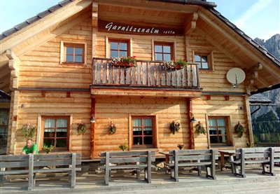
Two summits, one mountain: Gartnerkofel mountain embedded in the Carnic Alps has a southern and a northern summit - twice as many reasons to breathe some mountain air! Day trippers, mountain bikers and hikers alike enjoy glorious views from Garnitzen Alm pasture, located at the foot of Gartnerkofel. The Ardit hut is among the largest and most modern ones in the region, but has managed to preserve its rustic character. On the terrace, sun worshippers can stretch out in a deckchair and enjoy delicious food and drink at the same time. The "Hüttenburger" is an absolute top seller: bread for the burger is made by the Kandolf bakery in Hermagor, and the cheese comes from neighbouring pastures. All dishes served in the hut are based around fresh, regional produce, and everything - from Kaiserschmarrn to Kärtner Nudeln - is handmade. A treat for "meatatarians" is the beef stroganoff with Carinthian beef, served in a frying pan. Gourmets might want to sample the fresh ricotta and yoghurt. After you’ve been fed and watered, embark on a tour of the neighbouring pastures - Ofen Alm, Watschiger Alm or Auernig Alm. More ambitious mountaineers may explore Garnitzenklamm gorge, Nassfeld Pass or Gartnerkofel mountain, or cross the border into Italy. The imposing summits of the Carnic Alps will be at your feet like an endlessly wide carpet made of stone. Check the storage space on your camera before your hike - you'll need it!

Großfrondellalm pasture is a small, remote communal pasture of the Grafendorf neighbourhood, located high above the mountaineering village of Mauthen near the Italian border. The production of high-quality cheeses such as Gailtaler Almkäse and “Schotten” cheese as well as butter has a long tradition on the pasture. Cows are kept here during the summer months, grazing on the steep slopes together with a few goats. The kettle-shaped area also contains an ice tongue that usually remains intact throughout the summer. Großfrondell is well-known among hunters, due to its abundant wildlife stock of chamois, grouse and red deer. No matter what brings you here - you will be served a sustaining platter of cheese, speck and homemade sausages. The stone hut already functioned as a supply base for soldiers at the front during WWI. The path leading up to the hut with its 103 serpentine bends was constructed over just 13 days in 1915. Today, hikers may take the historic trail up to Köderhöhe, where a summit cross was constructed not long ago. There is also the option of "shadowing" the dairy workers as they go about their tasks. The pasture is sometimes also referred to as the "Grafendorfer Alm", due to the fact that the members of the farming community come from Grafendorf.

The early bird catches the worm - or, in this case, a whole breakfast at the Kohlrösl hut high above the Gitschtal valley. Getting up early is well worth it to see the sun rise from the hut and to enjoy the one-of-a-kind panorama and light. But the hut also warrants a visit later in the day: at lunchtime, visitors may look forward to delicacies from the region, served on the sunny panorama terrace. In the afternoon, there is coffee and cake or a traditional "Brettljause", cold cuts served on a platter. In the evening, try a hearty "Frigga" made from Gailter Almkäse cheese. If you don't feel up to the hike back down to the valley, spend the night in the hut and enjoy one more sunset with far-reaching views across the valley. The view from the summit of Golz mountain is even more breath-taking: Kohlrösl hut is a good starting point for a hike up the mountain, which offers stunning all-round views of the neighbouring valleys. The hut itself dates back to the 1940s, when the building materials were carried up the mountain by mules. Today, the hut has been given a thorough makeover and a new lease of life. The young generations still preserve the customs of old, such as the traditional "Almkirchtag" festival or atmospheric evenings with music and "Schuhplattler" dancing. The Kohlrösl-Buam dance group dedicated itself to "Schuhplattler" dancing as early as 1948 and has handed down its passion for 15 different pieces to their offspring.

Majestic Großglockner, the imposing Hohe Tauern range and the forbidding outcrops of the Carnic and Julian Alps - from Poludnig mountain, you can see them all. Astonishing, as the mountain itself is not even in the 2,000 m range, having missed that mark by just 1 metre! Nevertheless, the mountain offers many ways to explore the great outdoors, with romantic pastures where you can recharge your batteries along the way. A popular image for snapshots is a picture taken at the summit cross, with one foot in Austria and the other one in Italy - the state border runs directly across the summit. The views are overwhelming and, best of all, the hike to the top is not too difficult. The view of the valley down below opens up unique perspectives. An attractive round trail leads from Poludnig Alm pasture up to the summit in about 90 minutes, starting from Hochmulde on the northern side of the mountain. If you prefer a less steep approach, stick with the pastures and continue up to Egger Alm or Dellach Alm. Either way, don't miss out on the food and drink on offer at the "Jausenstation" at Poludnig Alm pasture, part of the ten huts that constitute the core of Poludnig Alm, together with the shared stables. Guests will be treated to regional products of the finest kind by the landlady herself. As the region's "star product", Gailtaler Almkäse cheese is an integral part of a proper Carinthian platter of cold cuts and cheeses. Enjoy!
Rattendorfer Alm pasture is an absolute gem in the Carnic Alps, first mentioned in a document from 1403, when it was still called "Schellekalm". The livestock count was recorded precisely, with almost 600 cows and goats grazing on the pasture during its heyday. Eleven dairies and 16 herdsmen farmed the pasture during the summer months. Today, things are a little more quiet - what has remained the same, however, is the traditional production of Gailtaler Almkäse and other Alpine dairy specialties such as "Schotten" cheese, butter, yoghurt and hard cheese. Then and now, visitors to the pasture can expect wholesome treats from the dairy. In fact, Rattendorfer Alm pasture is a perfect destination for a family hike. For a comfortable walk across the border to Italy and back, follow the cheese-themed circular trail ("Käserundwanderweg"), or take the kids on a proper mountain tour up the Zottachkopf summit. The soldier-themed circular trail holds a wealth of information about the old emplacements from WWI, and a memorial chapel reminds us of all those who lost their lives. Climbers might want to make their way up the Trogkofel, while mountain bikers can choose between different tours hopping from one pasture to the next. Whether you arrive walking, climbing or pushing pedals: Rattendorfer Alm pasture affords beautiful views across the valley and the surrounding peaks. Overnight accommodation is also on offer, as are traditional Alpine fairs and a festival to mark the return of the livestock to the valley. The pasture may be reached via a well-maintained gravel path.
The trail up Reisacher Joch Alm pasture is wonderfully quiet - in fact, the only sound you'll hear will be your hiking boots crunching the gravel underfoot. Be prepared to stop for a rest several times along the way, not just to catch your breath, but to let your gaze wander across the beautiful mountain panorama. This spot, embedded in the Gailtal Alps, affords fantastic views of the Carnic Alps and the entire Gailtal valley. The last stretch before your reach your destination is nothing short of spectacular, with the rustic hut of the Reisach Joch Alm, nestling against the the imposing massif of the Reißkofel, being visible from afar. The location alone makes the pasture a popular destination for hikers and mountain bikers: it is perfect for reviving flagging spirits before hiking up the Reißkofel. For mountain bikers, the pasture marks the highest point of the circular trail. There is also a small petting zoo for young visitors. In addition to the dairy farmers and the hospitality staff, numerous cows, sheep and horses spend their summer up Reisacher Joch Alm. The entire milk yield is used to make the famous Gailtaler Almkäse, right here on the pasture. "Schotten" cheese, butter, buttermilk and curds are also made on site. Hikers can fortify themselves with bacon and sausages from the farm - best enjoyed in a sunny spot! In August, a traditional mountain festival with a mass is celebrated up here.
Really switch off, take a deep breath, live in the moment - Straniger Alm pasture, nestled against a breathtaking natural backdrop near the border to Italy, is the perfect place to do just that. The pasture may be reached via a well-maintained gravel path. For long-distance hikers, the pasture on the southern mountain ridge of the Gailtal valley is a great place to rest and one of the most important overnight stops on the Karnischer Höhenweg trail and the Via Alpina between Plöcken Pass and Nassfeld Pass. For mountain bikers, Italy is just a short ride away. Hikers may continue on the cheese-themed circular trail, visit nearby Kordin Alm pasture, or make their way up Waidegger Höhe, Schulterkofel or Hochwipfel mountain. To top up your supplies or purchase some goodies to take home with you, pay the small farm shop a visit. The pasture is farmed by a community from the surrounding villages. Traditional dairy skills are still cultivated on Straniger Alm: Gailtaler Almkäse is made, matured and stored here based on an original recipe. The cheese that owes its savoury note to a small amount of goat's milk is left to ripen in a natural rind. The ancient knowledge of cheese-making is passed on here through workshops and courses. Tours of the pasture, including tastings of its various products, are also organised on a regular basis. Visitors can expect lovingly and creatively prepared dishes, using produce straight from the farm. The pasture and its hut are known for their convivial, relaxed air. Guests quickly turn into friends who return time and time again!
Action-packed fun, tranquillity and nature, culinary highlights and expert knowledge: on Treßdorfer Alm pasture, all these attributes unite to provide a wonderful day out for all the family. The pasture has its own inn with rustic "Stuben", cosy rooms and a show dairy. Nearby Nassfeld Pass offers numerous round trails for hiking and walking, all with splendid views, via ferratas for climbing, a playground and summer sledding run for children and much more. As you can see, a trip to Treßdorfer Alm is never boring! Getting there is easy even for the little ones: from Nassfeld, a walking trail leads up to the pasture in just 25 minutes. It is also possible to take the car directly to the hut and start your hike in the surrounding mountains from there. Early summer is a particularly good time for a visit, from mid-June onwards, when the wulfenia flower is in bloom - a rare type of flower that is only found here. Towards the end of July, the Gailtaler Almkäse is cut, and the traditional "Kirchtag" festival is celebrated at the beginning of August. The show dairy is open daily during the summer months and offers visitors the chance of watching the dairy workers as they go about their business. Drop in at the farm shop afterwards or taste the home-made dairy products in the Almgasthaus! If you are hungry, opt for a cold platter that includes Gailtaler Almkäse, or a traditional Carinthian dish, prepared using fresh and regionally sourced produce.
Tröpolacher Alm pasture with its own dairy and refreshment point is located in an idyllic spot high above the Gailtal valley in the Nassfeld region, below the imposing Zweifkofel peak and near a reservoir. During the summer months, more than 50 dairy cows and around 90 young cattle graze here. Their fresh milk is processed into Gailtaler Almkäse cheese, butter, “Schotten” cheese and yoghurt in the pasture's dairy. If you drop in for refreshments, you will of course be served the dairy specialties made right here on the pasture, as well as hot dishes such as “Frigga”, bacon and eggs or goulash soup, all freshly prepared in the traditional way. Tours of the dairy and the barn are offered (registration is required). Tröpolacher Alm pasture is a perfect starting point for hiking tours in the Carnic Alps, for instance up Roßkofel or Trogkofel mountains in the immediate vicinity of the pasture. However, it doesn't have to be a long or strenuous hike: from the hut and its terrace, visitors enjoy splendid views of the Gailtal valley and the refreshing mountain air. If you would like to experience the pasture in the early hours of the morning or in the evening, you have the option of spending the night in the hut and be woken up by cowbells in the morning. Tröpolacher Alm may be reached via a well-maintained gravel path.

It is almost impossible to imagine that, millions of years ago, the imposing rock faces of the Carnic Alps were submerged in the Devonian sea. Over time, coral reefs emerged from the waters - today, they are the most impressive peaks of the Carnic Alps. Between the steep limestone rockfaces of the Kellerwand massif and Gamskogel mountain, in a particularly idyllic spot, lies Valentinalm pasture. The majestic presence of the "gentle giants" that surround the pasture is truly awe-inspiring. Valentinalm pasture is easily accessible via Plöckenstraße road and an ideal starting point for hikes. A classic tour, and arguably the one with the most stunning views, takes you up to Lake Wolayersee in about three hours, and you can conquer the Rauchkofel summit on the way if you wish. Experienced mountaineers may want to try the via ferrata on the Hohe Warte, the highest peak in the Carnic Alps with an altitude of 2,780m. For a leisurely family hike, we recommend the comfortable ascents to Obere Valentinalm pasture. With a bit of luck, you might spot a marmot or two! On the way back, tell your young explorers to keep an eye out for fossils - many stones have shells in them. At the end of your hike, reward yourself with a stopover at Untere Valentinalm pasture. The freshly made products from the region taste even better when served with glorious mountain views! The pasture also offers overnight accommodation.

HOW TO GET THERE: follow the trunk road towards Longarone, from Erto. After the Casso junction, a paved road on the left leads to Pineda, via Monte Toc (The Walking Mountain). Shortly before reaching Pineda, take a left onto the forest road (the Casera is clearly signposted - CAI 905 trail), which after a few steep sections, becomes an easy mule track. Cross a beech forest and after two short landslide-prone stretches, you will reach the Mesaz Stream bridge, which leads directly to the Casera. This structure is situated in a beautiful amphitheatre of the Alta Valle and overlooked by the majestic peaks of Monte Toc, Croda Bianca, Cimon di Valbona, Cime di Pino and Col Nudo.
On the foot of the Gartnerkofel lies picturesque Watschiger Alm pasture, surrounded by the imposing peaks of the Carnic Alps. A trip up Watschiger Alm is particularly worthwhile from early June until mid-July, when the wulfenia flower is in bloom around the hut, transforming the mountain meadows into a colourful sea of blossoms. Every year, plant enthusiasts from all over world come here to admire and photograph this unique flower that grows only in the Nassfeld region. The wulfenia flower is protected and picking it is strictly forbidden. It owes its pretty name to its discoverer, Franz Freiherr von Wulfen, who was the first to discover this blue flower that had previously not been recorded or described by any botanist, more than 200 years ago. If you feel like getting some exercise after soaking up the sun on the terrace, embark on a hike up the Gartnerkofel or, if you are pressed for time, pay nearby Garnitzenalm pasture a visit. Both trails offer beautiful panoramic views and hearty refreshments at the end, such as Gailtaler Almkäse, "Schotten", butter and hard cheese. Watschiger Alm may also be comfortably reached by car via a tarmacked road.
On the foot of the Gartnerkofel lies picturesque Watschiger Alm pasture, surrounded by the imposing peaks of the Carnic Alps. A trip up Watschiger Alm is particularly worthwhile from early June until mid-July, when the wulfenia flower is in bloom around the hut, transforming the mountain meadows into a colourful sea of blossoms. Every year, plant enthusiasts from all over world come here to admire and photograph this unique flower that grows only in the Nassfeld region. The wulfenia flower is protected and picking it is strictly forbidden. It owes its pretty name to its discoverer, Franz Freiherr von Wulfen, who was the first to discover this blue flower that had previously not been recorded or described by any botanist, more than 200 years ago. If you feel like getting some exercise after soaking up the sun on the terrace, embark on a hike up the Gartnerkofel or, if you are pressed for time, pay nearby Garnitzenalm pasture a visit. Both trails offer beautiful panoramic views and hearty refreshments at the end, such as Gailtaler Almkäse, "Schotten", butter and hard cheese. Watschiger Alm may also be comfortably reached by car via a tarmacked road.
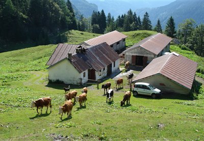
The Warmuth family's love of nature and mountain dairy farming is in their genes: they are the ninth generation to farm the Bischof farm in the upper Gailtal valley, a family farm of 300 years' standing. Traditionally, the farm livestock spends the summer on the Bischof pasture, divided into an upper and lower pasture. The location of both pastures is idyllic and well worth the uphill hike or mountain bike ride. To reach the lower pasture ("Untere Bischofalm"), follow the forestry road from the valley. It may also be reached from Zollneralm, on foot or by mountain bike, or via the Karnischer Höhenweg trail from the Plöcken region or Pramosio pasture on the Italian side. Bischofalm pasture is the only privately held pasture among the mountain dairies in the Gailtal valley. Despite the enormous work load, the family is determined to keep alive its cheese-making tradition that goes back hundreds of years, and to pass on the required skills to the next generation. Milk is made into Gailtaler Almkäse, butter and smoked "Schotten" cheese right here on the pasture. The Almkäse is wonderfully aromatic and full-bodied, and the "Schotten" is used in the kitchen in a variety of ways: served with cold platters and salads, deep-fried as a main dish or as a pasta filling. Unsmoked "Schotten" is even made into desserts. Unmissable flavours that alone make a visit worthwhile!

HOW TO GET THERE: head up the Cimoliana Valley from Cimolais (651 m) via the road that runs along the Cimo- liana Stream (please beware of the road con- ditions if it has rained heavily). You will reach the Pian Meluzzo after 13 km; at the junction for Val Meluzzo, continue left on the road until you reach a parking area at the start of the trail. Within minutes (10), this trail will lead you to the mountain hut situated between the Val Montanaia and the Val Meluzzo, at the slopes of the Meluzzo Peak. Services Luggage transportation, guided hikes available by reservation only. Restau- rant serving typical cuisine and locally-produ- ced products.

HOW TO GET THERE. for those coming from Veneto: take the Pian di Vedoia exit off the A27 motorway and fol- low the signs for Longarone - Erto. At Erto’s only roundabout, take the road for Zemola Valley and continue for 3.5 km. For those arriving from Friuli Venezia Giulia: Take the Pordenone exit on the A28 motorway and follow the signs for Maniago - Montere- ale Valcellino, until you reach Erto. At Erto’s only roundabout, take the road for Zemola Valley and continue for 3.5 km.

HOW TO GET THERE. the mountain hut can be reached on foot from Erto via the CAI 381 trail. Leave your car at the “Stei de Mela” car park and continue on foot. There is also the “sentiero del cava- tore” (quarryman’s path) which is clearly mar- ked. From Casso, you can arrive via the “Troi dal Sciarbon”, until it joins the CAI 381 path. From Erto, you can climb up ten kilometres or so to the Zemola Valley on a mountain bike. Services Educational hikes and guided tours to the old marble quarry open-air museum (1500 m) are offered. On request, Casera Mela offers a shuttle service (surcharge) for people with reduced mobility.

HOW TO GET THERE: from Erto (778 m), head up the Zemola Valley road which is open to traffic, until you reach Casera di Mela. Shortly before the Casera, the forest road branches off, follow this up to the second junction. Turn right at the jun- ction and continue straight ahead until you reach the Pian di Mandriz (1203 m), where the track ends and the trail begins (CAI 374 trail mark). When you have crossed the Gè di Pezzei Stream, you will start climbing into the woods and will reach the mountain hut in 90 minutes. The hut is 20 minutes from Maniago.

HOW TO GET THERE. take the Pordenone exit on the A28 motorway and continue towards Maniago and Montere- ale Valcellina. From here, continue towards Claut, take a left before entering the village and follow the Val Settimana road right to the end.

HOW TO GET THERE: from the centre of Forni di Sopra (the small village of Vico), go down to the Tagliamento River Bridge, where the CAI 362-marked road starts, near to the sports centre (881 m, car park, information board). It is closed to traffic, runs along the ski lifts and arrives at Palas in 20 minutes.The direct path from the small village of Andrazza also leads here. Park just after the village, near the bridge on the Tagliamento River (837 m). From this point, the mule track gently climbs through the woods, until it arrives at an easy-going, open, gravel area that leads to the shelter in 105 minutes.

HOW TO GET THERE. it can be reached from the town centre of Forni di Sopra, if you follow the 52 trunk road towards the Mauria Pass for 3 km until you reach Chian- darens (962 m). From here, there is a paved road on the left which can be used by cars up to the bridge on the Giaf Stream. When you have parked your car, you can walk along the forest road, or alternatively take the CAI 346 trail at 1107 m; both routes take approximately 1 hour. The mountain hut is situated above a forest area, at the base of the Coston di Giaf in the homonymous valley. The surrounding environment is typical of the Dolomites with its jagged peaks and bold, bare and smooth towers that contrast against the green forests on the gentle slopes of their base.

HOW TO GET THERE: situated in a beautiful location on the Pura Pass, between Monte Nauleni and Monte Tinisuta, the mountain hut can be reached from La Maina in Sauris by following the road along the Lumiei Dam which after several hairpin bends, leads to the Pass and conse- quently, the mountain hut. Alternatively you can arrive from Ampezzo (52 Carnia trunk road), and at 35.9 km, turn right for the Pura Pass at the Pura tavern.

HOW TO GET THERE: on foot, from Tualis, via the CAI 151 trail (3.5 - 4 hours), from Givigliana via the CAI 151 trail (3.5 hours), from Collina via the CAI 150 and 174 trails (3.5 - 4 hours) and from Ravascletto via the CAI 153 trail (4 hours). By car, motorbike or bike: from Comeglians, head towards Tualis, following the “Pano- ramica delle Vette”, or from Ravascletto to Casera Valsecca on a paved road. Then con- tinue on the dirt road towards Casera Taron- don, Casera Tarondut and Casera Crostis.

HOW TO GET THERE: the mountain hut is located on the Volaia Pass, between the Coglians and Capolago cliff faces and a short distance from the Volaia alpine pond. From the Tolazzi Mountain Hut (3 km after Collina), take the CAI 144 trail (2 hours). From the Marinelli Mountain Hut, take the Spinotti n. 145 difficult trail (2 hours) which requires suitable equipment.

HOW TO GET THERE: from Moggio, follow the road along the Val Aupa for 8.5 km until you are near the Bevor- chians tavern, then turn left onto a paved road until you reach an area called “Case Nanghets” (714 m). From here, follow the CAI 437 trail and after 1.5 hours of walking and around 500 vertical metres, you will reach the mountain hut. The Mountain Hut is loca- ted at the foot of the formidable and vertical northern mountain walls of the Gjai Peak and Creta Grauzaria. Luggage transportation via cable car is available, hikes with the nature guide Kaspar Nickles, climbing the walls of the Cima dai Gjai and the Torre Nuviernulis with alpine guides.

HOW TO GET THERE: from Val Pesarina: leave your car at the Cen- tro Fondo Coffee Bar (1236 m) and follow the CAI 201 trail (2 hours). From the Forcella Lavardet trunk road: after you reach Pian di Casa (1423 m), follow the forest road until the Mimoias alpine pasture and from there, the CAI 203 and 201 trails (2 hours). From Sappada: Start from Granvilla and take the CAI 316 trail via the Siera Pass (EE - skil- led hikers - 3.5 hours).

HOW TO GET THERE: from Sostasio (Prato Carnico village): follow the road which is at first paved and then par- tially-unpaved, w hich leads to Luch village and then the mountain hut, around 4 kilome- tres later. From Prato Carnico: reach the village of Còi by vehicle and then follow the CAI 226 trail near the acqueduct, upstream from the town, which leads through a steep forest near to the mountain hut (1.5 hours).

HOW TO GET THERE: from Rigolato climb up via the road until you reach Piani di Vas (1350 m). From here, continue on foot along the forest road for the easy CAI 228a and 228 trails (it takes 45 minutes or 1 hour respectively to reach the mountain hut). From Forni Avoltri: follow the CAI 229 trail for Casera Col di Mezzodì, until you reach the Sella di Tuglia (2.25 hours). From here, cross the mountains (trails 227 and 228) and, in 1 hour and 15 minutes, you will reach the mountain hut. From Cima Sappada: Follow the CAI 230 path that runs near to Monte Siera, up to the Tuglia Alpine Pasture. From here, continue until you reach Sella Tuglia and turn onto the CAI 227 signposted trail (for Campiut di Sopra Alpine Pasture, Piani di Vas and Rigolato). After a few metres you will reach a fork, where the scenic trail is [4}on the right. Head west and travel along the CAI 227 and 228 trails, via Casera Campiut (2 hours)Monte Tuglia, Monte Cimon, Creta Forata, Monte Pleros

HOW TO GET THERE: from Tolmezzo, follow the signs for Villa San- tina and then for Ampezzo, along the SS52 trunk road. At Mediis, turn right and continue until you reach Dilignidis. Services Luggage transportation and shuttle service available on request. Laundry facilities.

HOW TO GET THERE: from Sella Nevea follow the road that leads to Altopiano del Montasio. From there, take the easy mule track (CAI 624 trail) that cros- ses the ancient pastureland (60 minutes). Or, from the Guardia di Finanza barracks in Sella Nevea, follow the CAI 625 trail that climbs along the same route as the ski lift (45 minutes).

HOW TO GET THERE: from the Valle Rio del Lago: Take the forest road which leads to the Grantagar alpine pastures; continue along the CAI 628 and 625 trails, passing underneath the Parete delle Gocce. You will reach the mountain hut in a total of 2.5 hours. From Sella Nevea: Take the CAI 625 trail to the Cregnedul di Sopra alpine pasture and Scalini Pass. You will reach the mountain hut in a total of 2.75 hours. Luggage transportation via cable car.
HOW TO GET THERE: take the road from Sella Nevea that leads to the Montasio Plateau. At the end of the road (1502 m), follow the CAI 622 trail and in approximately half an hour, you will reach the mountain hut.

HOW TO GET THERE: the mountain hut is 2 minutes from the cable car station that ascends from Sella Nevea. It takes 2 hours to reach the hut on foot via the CAI 635 trail which starts from Sella Nevea. The mountain hut is located in the centre of the “Vallon di Prevala”, between the homonymous Sella and Sella Bila Pec, in the Monte Canin mountain range.

HOW TO GET THERE: from Tarvisio: head towards Sella Nevea, it is 2 km before the well-signposted town on the right. From Sella Nevea: approximately 2 km after the village, the mountain hut is located after the first hairpin bend, at the restaurant with the visible car park.

HOW TO GET THERE: from Valbruna: Travel for around 2.5 km along the Val Saisera road until you reach the P2 car park. A road that is closed to vehicles crosses the Saisera Stream. Follow the mule track up to the cable car station and the path then becomes steeper, beneath the rock walls. Take a left at the fork for Sella Prasnig and the path will become rocky and there will become rocky with some gravelly slides hairpin bends and a few springs, you will shortly reach the mountain hut (CAI 616 trail, 2 hours).

HOW TO GET THERE: once you have passed the village of Fusine, turn right towards the lakes, into the heart of the Tarvisio Forest. Follow the CAI 512 signposted trail from the upper lake, which is level at first and then begins to rise sharply. It leads to the moun- tain hut in roughly 1.5 hours.Forest. Follow the CAI 512 signposted trail from the upper lake, which is level at first and then begins to rise sharply. It leads to the moun- tain hut in roughly 1.5 hours.Forest. Follow the CAI 512 signposted trail from the upper lake, which is level at first and then begins to rise sharply. It leads to the moun- tain hut in roughly 1.5 hours. Luggage transportation - Sauna.

HOW TO GET THERE: continue towards Slovenia from Cividale del Friuli. At Ponte San Quirino, turn right and follow the signs for Savogna and then Masseris. 9 km later, you will arrive at the Mountain Hut.

HOW TO GET THERE: can be reached by car by if you head towards the Natisone Valleys and Clodig from Civi- dale, or from Castel monte if you head towards Tribil. On foot: From Paciuch to Drenchia if you take the signposted trail that leads to Bivacco Zanuso (4 hours). From Ponte Clinaz, along the road that leads to Clabuzzaro. Mountain bikes can also use this trail (4 hours).

HOW TO GET THERE: this recently-renovated mountain hut can be reached via an easy hike (approx. 1 hour) from Borgata Bach or Borgata Granvilla. From the mountain hut, you can continue along Trail No. 141 for a moderate-difficulty hike to the Lakes of Olbe or you can climb to the top of Mount Ferro.
HOW TO GET THERE: you can comfortably arrive by car from Sappada, or you can arrive on foot via a trail that crosses through a Norway spruce forest. Take the road that passes between the village’s houses in Cima Sappada, until you reach the turn for the Springs of the Piave River and Val Sesis. After a short uphill ramp, cross the main road and then take the trail that leads straight to the glacial sediments, where the Piave River flows. It takes 45 minutes to reach the Piani del Cristo Mountain Hut from Cima Sappada.

HOW TO GET THERE: the mountain hut can be reached via the comfortable Sappada 2000 chairlift or a medium-difficulty hike (2.5 hours). You can reach the Lakes of Olbe via an easy hike (approx. 1 hour) from the Sappada 2000 Mountain Hut or you can continue to the Mulo Pass and the summit of Mount Lastroni, where many traces of the First World War can still be seen.

HOW TO GET THERE: take the Pordenone exit on the A28 motorway and continue towards Maniago and Montere- ale Valcellina. From here, continue towards Barcis and turn left before entering the village, to reach the other side of the lake. Turn right at the first junction and then follow the road signs for the Mountain Hut.
The shelter can be reached by climbing the carriage road from Clau along the Val Cellina (CAI n.966). The malga is surrounded by a grassy plateau, characterized by alluvial deposits. Theropod footprints were discovered nearby, and are considered to be one of the most important pieces of evidence for proving the presence of dinosaurs in Italy.