The alpine pastures also produce butter, which is obtained from the cream that surfaces from the evening milk. The traditional mechanical method of obtaining butter is called churning and consists
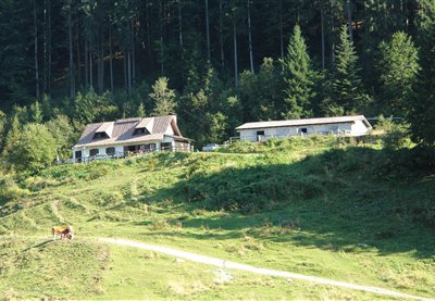
The Glazzat Bassa Alpine pastures are used at the beginning and end of the grazing period. Here thrive such species as the Alpine clover, the bearded bellflower, the wild geranium and various ferns. The Glazzat Alta pastures and hut structures (1,348 m), with its additional rural tourism activities, are part of this facilities.
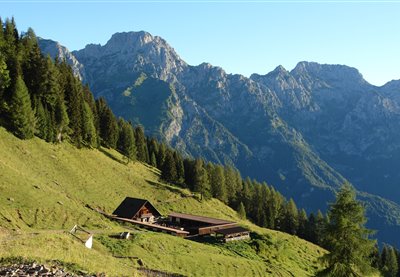
The structure rises near the Pramollo pass and between June and July its fields are home to the blooming of the magnificent Wulfenia carinthiaca, a protected botanical species discovered in 1779 and only present in very few areas (Albania and Montenegro, the Himalayas and Asia Minor). This plant is protected due to its rarity and a special celebration is organized here during its flowering period.
The malga is located within the Julian Prealps Park and a didactic itinerary has been created next to the structure. In Resian "Coot" means corner, and indeed this malga rises on the corner of the valley. The "Sentiero per tutti" (lit. “Trail for all”), dedicated to excursions for disabled visually impaired individuals, can be found in the Pian dei Ciclamini area.
The malga was recently restructured, while retaining its original architectonic characteristics. Nearby, you can visit Lake Malins and observe the many newts that inhabit its waters. This picturesque Alpine landscape is particularly suggestive, due to a gorgeous view of the Pesarine Dolomites. By proceeding left from the shelter, you can reach malga Vinadia Grande and then descend towards the Pesarine Valley.
Lying at a comparably low altitude, its pastures are grazed between mid-May and mid-October. The grassy saddle of Navas (1,025 m) overlooks the Degano valley, northward, and is dominated by the calcareous massifs of the Monti di Volaia and by the Monte Coglians to the north, while you can admire the plateau of Lauco and its hamlets to the south-east.
The structure was built near the peak of the homonymous mountain, in a location characterized by its suggestive beauty. This splendid panoramic position makes it a spectacular observation point looking onto nearby Alpine peaks such as the Çuc dal Bôr, Mount Cavallo, the Montasio Jôf and the Mangart. The area is inhabited by deer, roe deer and corncrakes.
The main door of this malga features carvings and engraved initials that reveal the artistic skills and passions of the many malghesi and shepherds who lived here over the course of time. The malga is open in the intermediate grazing period, while its activities move to malga Ielma di Sotto during the initial and final pasturing phases. Similarly to a few other shelters in the region, the traditional boiler for milk processing, known as the “musse”, has been conserved in Upper Ielma. Above the basin where the malga is located, the slopes of the San Pietro Hill are peppered with larches, spruce trees and a few specimens of beech trees, while many raspberries can be found in the undergrowth. This malga offers a spectacular view of the Pesarine Dolomites. By crossing the pass from Upper Ielma you can descend towards the Pieltinis shelter and then to the Sauris basin (CAI trail n. 218).
Similarly to a few other shelters in the region, the traditional boiler for milk processing, known as the “musse”, has been conserved in Lower Ielma. The first documents referring to this malga date back to as early as the thirteenth century. Above the basin where the malga is located, the slopes of the San Pietro Hill are peppered with larches, spruce trees and a few specimens of beech trees, while many raspberries can be found in the undergrowth. The malga is open during the first and last weeks of pasture, while activities move to malga Ielma di Sotto during the intermediate period. By proceeding leftwards from the crossroads - located shortly after the shelter - visitors can reach San Giacomo; by proceeding straight ahead from here, you can climb a few short hairpin bends towards the nearby Ielma di Sopra shelter and then towards malga Pieltinis.
Above the pastures of malga Meleit is the peak of Mount Dauda (1.765 m a.s.l.), offering a majestic view on the valleys below. In order to reach the peak, you should proceed eastwards and, when the path starts its descent, take the trail on the right which traverses the ruins of the Chiâs di Sopra shelter and leads to the southern ridge of the mountain. From here, follow the crest leftwards to reach the peak. From the shelter, visitors can also reach Villa Santina or Zuglio. To get to the former, descend rightwards to reach Val di Lauco, Vinaio and Lauco; to reach the latter, proceed to the left until you get to malga Dauda, the Fielis hamlet and finally Zuglio.
The abundance of green alders makes this malga an ideal environment for goat grazing. A particularly interesting plant one may encounter in this area is the Rhodothamnus chamaecistus. By walking downwards from the Valuta shelter you will leave the detour towards Monteriù to your left and lose altitude until you encounter the confluence between the torrents Novarza and Pieltinis; from here, you can climb back upwards towards the path that connects Lateis di Sauris to the malghe of the district.
On the first Sunday of August, mass is held for the Alpine troops in the chapel next to the Malga, in memory of the discovery of the Redeemer during the Great War: the chapel was built by Alpine troops specifically to protect this finding. The pasture is called Pizzul because the Malga was split in two parts and this word means “Small” in the Friuli dialect. From the shelter, visitors can climb towards the Pizzul pass and descend from there directly to Cason di Lanza (CAI trails n. 441, 442, 442A). If on the other hand they choose to follow the dirt road, this will lead them to the nearby malga Paluchian (CAI n. 441B). The first historical document to reference the area indicates that animal grazing took place in malga Pizzul as early as the summer of 1295.
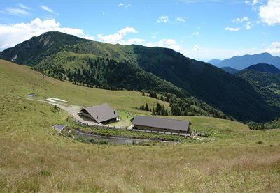
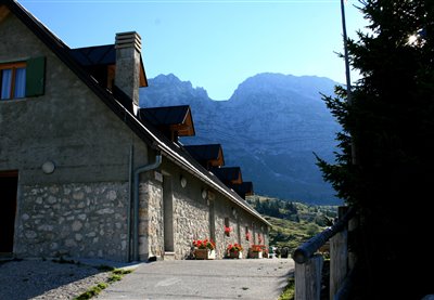
The dairy hut, also known as "Paronuzzi" is the most important alpine farm of the Cansiglio-Cavallo hogback. Located near the Piancavallo tourist resort, this farm is the only old high-altitude production units on the plateau that is still in operation.
This pasture plays an important role for the grazing sector due to its majestic nature. Near the malga is the usually dry riverbed of a branch of the Rio Losa, where you can observe alpenroses, hairy alpenroses, specimens of erica carnea or spring gentian. By proceeding on CAI trail n. 220 you can reach malga Forchia and descend towards Ovaro; above the Forchia shelter, visitors will find the start of the path leading up Col Gentile to an altitude of 2.075 m a.s.l. (CAI trail n. 235).
The pasturing area - which consists of various environments, the grazing space, the buildings, the wood and the waterholes - is frequented by numerous bird species, such as black redstarts and yellowhammers that find ideal feeding and nesting conditions in this area. However, the large amount of small birds also attracts their most deadly predator, the Eurasian sparrowhawk. By proceeding beyond the shelter, you will reach malga Pieltinis and the homonymous mountain (CAI trail n. 206).
The entire mountain range extending between Mount Rivo to the West and the peak of the Tersadia to the East is located in a central and isolated position from the Carnic area. These peaks offer breathtaking 360° views: from the High Tauern to the North all the way to the Adriatic Sea to the South, from the Dolomites located to the West to the highest peaks of the Julian Alps to the East. This ridge was used as a defensive system in the front line area during the Great War. Immediately under the peak are noteworthy remains of fortifications, walkways, trenches, tunnels and barracks. The malga complex known as the “Valmedan-Cucco” is located on the southern side of Mount Tersadia; from here, we highly recommend the excursion towards the suggestive peak of Mount Tersadia, at an altitude of 1.959 m a.s.l. (CAI trail n. 409), and the descent to Treppo Carnico in the Pontaiba Valley. From malga Valmedan Alta, you can also reach the Cucco shelter (on CAI trail n. 409) and then climb towards the homonymous peak at an altitude of 1.804 m (CAI trail n. 408°).
The 360° degree view allows observers to admire the Adriatic Sea, Mount Lussari and the Grosslockner. The nearby Mount Tenchia is the location of the "witches plateau", shrouded in legends concerning secret meetings between local and Nordic witches. This local myth inspired the poem "In Carnia" by Giosuè Carducci. Outcrops of effusive volcanic rocks can be found in the small lakes of Zoufplan. Here, the local Civil Protection has built a building to house a weather radar and tools for detecting seismic movements. From the malga, you can climb to Mount Tenchia, to the Zoufplan lakes and to the panoramic Cimon di Crasulina; from here, you can follow CAI trail n. 154 along the entire Tarondon – Pezzacucco – Crostis ridge.
Also known as the "Schenewelde" farmhouse, the structure rises nearby the homonymous pass, in a small panoramic valley surrounded by an unspoiled natural environment. A particularly noteworthy landmark is the "Tiziana Weiss Naturalistic Trail", one of the first self-guided trails of the Region.
This entirely restructured shelter has retained its ancient architecture thanks to a meticulous recovery of the ancient stones that made up the original walls of the building. After returning to malga Ielma di Sotto, you can proceed leftwards towards the Jelma pass and descend towards the Pieltinis shelter and then to the Sauris basin (CAI trail n. 218).
This malga is located on the North-West flank of Col Gentile, and from the peak of this mountain you can enjoy a magnificent view of the green Losa, Navarza and Torondon mountain range, of the glacial valleys that cross its southern flank and of the Creta Forata on the background. By climbing northwards, visitors can reach the Malins and Festons malghe and descend towards Upper Sauris (CAI trail n. 204); if they choose to proceed southwards, CAI trail n. 206 will lead to the Pieltinis and Gerona malghe and then descend towards Lateis di Sauris.
CAI trail n. 402, which connects Pramosio to Malpasso, features the memorial plaque dedicated to Maria Plozner Mentil, killed while carrying supplies to the frontline. Her story and that of all Carnic Bearers was progressively forgotten up until 1997, when the former President of the Italian Republic Scalfaro awarded these historical figures with the Gold Medal for Military Valour. From the Pramosio Pass you can visit numerous First World War sites and structures such as tunnels, trenches and posts. Malga Pramosio is the location of the only medieval mining tunnel in the eastern Alps, still intact in its original state. By proceeding beyond the shelter on CAI trail n. 402, you can reach the Malpasso ricovero Morgante shelter, the shelter of the Manze and, at an even higher altitude, the Upper Pramosio shelter with the splendid Lake Avostanis, surmounted by one of the most beautiful cliffs in the eastern Alpine range.
The pastures of malga Pieltinis cover the entire East flank of the homonymous mountain and the valley line beneath the peak features one of the richest heath areas in the whole Carnic Alps range. In addition to Alpine rhubarb, the meadows next to the malga also feature Alpine Timothy-grass, dandelions and specimens of Campanula scheuchzeri. From the Pieltinis shelter visitors can climb rightwards, traverse the Ielma pass and descend towards the Ielma di Sopra and Ielma di Sotto malghe before reaching the Pesarine Valley (CAI trail nThe pastures of malga Pieltinis cover the entire East flank of the homonymous mountain and the valley line beneath the peak features one of the richest heath areas in the whole Carnic Alps range. In addition to Alpine rhubarb, the meadows next to the malga also feature Alpine Timothy-grass, dandelions and specimens of Campanula scheuchzeri. From the Pieltinis shelter visitors can climb rightwards, traverse the Ielma pass and descend towards the Ielma di Sopra and Ielma di Sotto malghe before reaching the Pesarine Valley (CAI trail n. 218); turn leftwards from the lodges to traverse the Pieltinis pass and descend towards the Vinadia Grande malghe (CAI trail n. 204).. 218); turn leftwards from the lodges to traverse the Pieltinis pass and descend towards the Vinadia Grande malghe (CAI trail n. 204).
The green alder shrubs near Malga Vinadia Grande are an ideal habitat for black grouses. Climbing northwards visitors can reach the Malins and Festons malghe and form there they can descend towards Upper Sauris (CAI trail n. 204); by proceeding southwards, you will reach the Pieltinis and Gerona malghe and descend towards Lateis di Sauris (CAI trail n. 206).
From Paularo, you can follow indications for the Cason di Lanza pass and, after passing the Lower Ramaz Shelter, reach the Lower Meledis pastures in less than one kilometre. The malga is open during the first and last weeks of pasture, while activities move to malga Meledis Alta during the intermediate period. By proceeding along the road, visitors can climb to the Lower Valbertat shelter and, by turning left from here, reach malga Valbertat Alta. From here, they can enter the Austrian territory on CAI trail n. 449 and proceed to malga Straniger.
The Montasio plateau, a place of extraordinary beauty, is the largest grazing area in the entire region. The following malghe are all located in this district: Cregnedul di sopra, Larice, Parte di Mezzo and Pecol, dedicated to cheese production and agro-tourism. The history of the area describes the birth of Montasio cheese at the start of the thirteenth century, thanks to the Benedictine monks from Moggio Udinese. From a naturalistic point of view, in this area visitors can encounter rooster combs, broom flowers, marmots, deer, chamois, roe deer and foxes. From the Plains of the Montasio, you can return to Sella Nevea and descend towards Tarvisio via the town of Cave del Predil with its charming lake. Starting from the Pecol shelter, you can also easily reach the Giacomo Di Brazzà Refuge (on CAI trail n. 622), a splendid balcony looking onto the Mount Canin range.
The structure is open during the intermediate pasturing period, while its managers carry out their initial and final pasturing period activities in malga Ramaz instead. The structure is located on the southern slopes of Mount Lodin, characterized by Silurian rocks of marine origin that contain many invertebrate fossils, such as those of cephalopods with their characteristic shells. Corals are also frequently found in this area. The shelter is located on the “Carnic Crossing” and “Carnia Trekking” trails. From the malga, visitors can climb to the Lodinut pass (CAI trail n. 457), and by proceeding leftwards from there (CAI trail n. 403) they can reach Lake Zollner See in the Austrian territory, easily get to the Pecol di Chiaula pass and descend to the Pietro Fabiani refuge (CAI trail n. 454), therefore completing a circle and reuniting near the Upper Lodin shelter with the path that led them up the mountain.
During the war, this shelter was the logistics centre of the valley and it still features the remains of military shelters, as well as a cave known as the “Company of the Brigands”. A small church was built near the malga to commemorate the fallen soldiers from the Gemona Battalion. The farmhouse is the result of restructuring operations on the shelter that had been abandoned during the early 1950s, when traditional grazing activities no longer took place here: its recovery further valorises one of the many historical sites of the valley. From here, you can enjoy views of the Jôf del Montasio and the Julian Alps range. From a naturalistic point of view, in this area you will find: wild orchids, roe deer, chamois, deer and lynxes. From the malga, you can climb towards Sella Sompdogna, reach the homonymous malga and, from there, proceed even further towards the Grego Brothers Refuge.
The malga is open during the first and last weeks of pasture, while activities move to malga Lodin Alta during the intermediate period. The Stua di Ramaz is located nearby, East of the Chiarsò torrent. The site takes its name from the large barrier (“stua”= enclosure) once built to facilitate the transportation of timber towards the valley. On July 15th 1944, while exploring the north-eastern Carnia mountains, German soldiers killed some shepherds in Malga Cason di Lanza and Malga Confin e Meledis. A memorial stone featuring the writing “peace to the fallen ones – aid to themselves” was erected in 1946 to commemorate the victims from Lanza and Cordin, and can be found on the path leading from Paularo to Cason di Lanza via the Ramaz Shelter. From the shelter, visitors can reach the Cason di Lanza pass and either proceed on the road towards Pontebba or follow CAI trail n. 454 towards the Fabiani Refuge.
In 1478, on Plan di Lanze, a violent battle took place between the Turks – who were trying to cross the pass – and Venetian troops flanked by Carnic militias. The Turks were defeated and pushed back, and the Carnia area was therefore saved from their dreaded raids. According to legend the name, Plan di Lanze, derives from the lances abandoned on the battlefield by the defeated Turks. A didactic rocky gym has been built at a distance of just approximately one hundred metres from the shelter. This site offers a magnificent view of Mount Zermula and of the Creta di Aip. The shelter is the ideal starting point for many excursions, including climbs towards Mount Zermula (2.143 m) (CAI trails n. 442 and 442A), or towards the Lomasti bivouac, via malga Val Dolce and the Aip Valley (CAI trails n. 439 and 440).
From the start of the Mount Croce Carnico Pass terrace, proceed leftwards along a dirt road (CAI trail n. 161) to reach the nearby malga Collinetta di Sotto in just a few minutes. Along the way, you will encounter various inscriptions marking the “Via Julia Augusta” that once connected Aquileia to Noricum through the Mount Croce Carnico Pass. The Austrian flank near the pass is the location of the first recoveries of Great War posts for the outdoor history Museum that develops all the way to the peaks of the Pal Piccolo (1.866 m), Freikofel (1.757 m) and Pal Grande (1.809 m). From here, you can proceed westwards on CAI trail n. 148, leading to the road towards malga Val di Collina, malga Collina Grande, malga Plotta, the Monumenz shelter and the Marinelli refuge.
Starting from this pasture, which offers a fascinating view of the Dolomite range, visitors can reach the trail climbing from Cima Sappada towards the Source of the River Piave and the “Pier Fortunato Calvi” Refuge. The southern flank of Mount Avanza, which dominates this pasture, features ancient copper and silver mines still containing the remains of pestles used for the crushing of minerals. This area of noteworthy historical value can be reached by following CAI trail n. 173, starting from the hairpin bend located 100 m to the East of the shelter and climbing steeply towards a crossroads where visitors should follow CAI trail n. 177 to the right.
The structure rises on the southern-east side of Mount Punta Bella. From this panoramic point you can enjoy a view on the Valle del But, on Val Lauco, on Val Tagliamento to Prealpi Carniche and Marano lagoon. Its position is strategic in the hiking and cycling scene.
The malga is open during the intermediate pasturing period, while its managers carry out their initial and final pasturing period activities in malga Meledis Bassa. Visitors can observe Austrian trenches from the Great War on the Puartis Valley Peak, slightly above the shelter. On July 15th 1944, while exploring the north-eastern Carnia mountains, German soldiers killed a few shepherds on the Lanza and Cordin malga. These victims are celebrated by a memorial stone featuring the words “peace for the fallen ones – aid to themselves”, located on the path leading from Paularo to Cason di Lanza via the Ramaz Shelter. From the shelter, you can reach the Upper Lodin malghe (on Cai trail n. 448B), or choose to turn right and cross the Malinfier brook, reach the Meledis pass and descend towards malga Straniger, in Austria.
On the asphalt road from Paularo, follow indications towards the Cason di Lanza Pass and turn right in the “Baita da Nelut” area onto a very steep forest path (CAI trail n. 442) that climbs towards the Zermula shelter. Along the path from Paularo to the malghe, approximately one kilometre after the “Maina della Schialute”, visitors will find indications for a short trail leading to the “Palm”, a prodigious secular white fir tree listed among the main natural monuments of the Friuli Venezia Giulia region. Trenches dating back to the Great War can still be found nearby the malga. Proceed on the road built during the First World War to reach the peak of the panoramic Mount Zermula (2.143 m).
This malga was rebuilt after being destroyed by an avalanche during the 1980s. From the Moraretto shelter, visitors can follow a road or CAI trail n. 143 to the Giovanni Marinelli Refuge (2.111 m), built in 1901, and then descend along CAI trail n. 148 towards the Mount Croce Carnico pass. The pastures extending between the shelter and the Marinelli Refuge are home to a large colony of marmots. The hamlet of Collina in the Forni Avoltri area is particularly important for the regional dairy sector, given that the first local dairy production cooperative was founded here in 1881: the building still stands here with its ancient sign.
Dirt roads may include fairly bumpy stretches, especially after unfavourable weather; in particular, the descent from the Corce saddle to the ruins of the Dolaces farmhouses. In the densely-growing brushwood shrubs lives a nice, peculiar animal: the dormouse, a small rodent of the Gliridae family with a bizarre tail which is longer than its body and moderately prehensile. This allows it to move acrobatically around bushes.
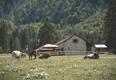
The structure is surrounded by an actual natural botanical garden, featuring great yellow gentian, wild gladiolus and carnations. The homonymous mountain appears as a grassy pyramid from which the viewer can observe the entire Friuli region. The top of the mountain houses the small Church of the Redeemer. Near the malga is the start of the downhill trail.
The panoramic view on the breathtaking naturalistic landscape you can enjoy from this malga covers the entire plain of the Friuli region and, on particularly clear days, the viewer’s gaze can travel all the way from the course of the Tagliamento River to the Adriatic Sea. Griffons are known to circle in the skies of this area, while the fields are inhabited by feral horses (Koniks).
The structure is located on a grazing saddle on the border of the Julian Prealps Natural Park, on the mid-southern flank of Mount Lavara. The shelter is surrounded by unspoiled nature, where walkers may encounter roe deer, chamois, ibex, marmots, eagles and many other animal species.
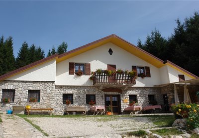
The Pancotto family has managed the malga, farm restaurant and didactic farm since 2011, offering children and kids the opportunity to spend a week discovering life in the pastures.
The Alpine farm is located inside a doline, a karstic depression called "fossa" in the local dialect. Under the new facilities the remains of the old buildings can still be discerned. The natural or man-made water pool is called "lama". The entire district is marked by these small hollows with impermeable bottoms where rain water and melting snow gather.
The Alpine farm is located in a small hollow at the feet of the Col Scarpat and also includes the pastures of the Bos and Busa Bravin farms, whose long abandoned facilities are no longer recognizable. The stony pastures characterize the farm, as does the juniper, a plant usually avoided by animals because of its stinging leaves. The location of these pastures offers a broad view over the whole Friulian Alps range.
The farmhouse is located in an old building which has retained all of its ancient charm, surrounded by hills and beech woods. The malga (mountain hut) is located in the southernmost part of the Cansiglio Forest, the second largest in Italy and one of the most important environmental resources of the entire region. The Patriarca trail passes in front of the malga.
This pasture is very rich both in terms of wildlife and from a naturalistic point of view, thanks to the presence of nettle, ferns, yarrow and mountain sage. The renovation of the buildings involved the historical recovery of the old shelter as a testimony of ancient life in the pastures.
Stop - I think I saw something move up there on the rock! Slow down your steps, lift the binoculars up to your eyes - and there it is. Not far from the trail leading up to Rudnig Alm pasture, a marmot has come out of its hiding place to sunbathe on the rocks. A wonderful sight for mountaineers! The chances of spotting a marmot are highest during the early hours or late morning, when the trails of the Carnic Alps are not yet busy. Head along the gravel path up to Rudnig Alm at dawn, where you can watch the beautiful colours of the sunrise while enjoying a proper mountain breakfast with home-made delicacies aplenty - Gailtaler Almkäse, fresh butter, "Schotten" cheese, curds and soft cheeses from the mountain dairy. Rudnig Alm pasture is located just below the Roßkofel and Troghöhe mountains. From the hut, climbers can get up the Roßkofel in approximately three and a half hours. The Rudnigsattel is a 45-minute hike away. The pasture makes an ideal starting point for hiking and climbing tours, and there is also the option of staying overnight. If you prefer to take it easy, explore the spacious pasture surrounding the hut and enjoy the fantastic panoramic views of Nassfeld Pass and Madritschen mountain and the nearby reservoir. And who knows, you might even spot another marmot on the way back!
The pointed cone of the Findenigkogel (Monte Lodin) at the Italian border is visible from afar. As charismatic as the mountain itself is the gnarled wooden cross on the summit and the splendid views across the Carnic Alps. Hikers descending to the foot of the Findenigkogel or mountain bikers who explore the area of the former World War I front will pass the rustic Achornacher Alm pasture just below the Karnischer Höhenweg trail and can expect a lovingly prepared snack, using home-made dairy products. Specialties included Gailtaler Almkäse cheese (protected status), fresh butter and a tender soft cheese. The so-called "Schotten" is also served here, a curd-like, crumbly cheese made from butter milk without pressing. Achornacher hut is a Mecca for cheese connoisseurs, and cheese from the pasture has made it onto the winner's podium of mountain cheese contests several times. Cheeses are judged on their internal and external appearance, on fragrance and on flavour, and the Gailtaler Almkäse was able to convince the highly critical gourmets in every respect. It is worth setting aside more time for a visit to the hut in order to sample the culinary highlights while basking in the glorious panoramic views!
A sparkling blue sky, lush green mountain pastures, a far cry from the hustle and bustle of the outside world - and yet so close: Dellacher Alm pasture is the perfect destination for all those yearning for a break from the everyday routine and keen to replenish their energy levels by going offline in a beautiful mountain setting. Up here, there is no mobile phone, radio or television signal. Entertainment is provided by nature, and nothing else. However, there is no question of things getting boring: kids can roam around and let off steam to their heart's content, the adults can have a chat at the fountain or soak up the sun on the little bench outside the hut. Dogs are also welcome up here. If you really can't bear the thought of leaving so soon, simply rent one of the 25 huts available. In total, Dellacher Alm consists of 36 huts, original structures made from stone and timber. Some even come with a traditional roof made of wooden shingles, such as the Almgasthaus inn that is run by the Pipp family, where guests are treated to regional delicacies such as the Gailtaler Almkäse cheese or freshly made butter. No one has ever left this place hungry! Dellacher Alm pasture is easily accessible via Egger Alm pasture - simply follow the road past wildly romantic Lake Almsee. After an approximately 3.5km walk, you will reach the pasture of Dellacher Alm, which also makes a great starting point for hikes, for instance up the Poludnig peak and Poludnig Alm pasture.
Just a few steps uphill from Egger Alm pasture is the perfect spot for having a rest on the mountain meadow, amidst blooming herbs and with wonderful views to boot. Let your gaze wander across the 47 huts, the veterans' chapel of the mountain village, the lush forests and further on across Lake Presseggersee to the other side of the valley, where the Gailtal Alps present themselves from their best angle. But it is not just the wide-open vistas that make this high valley with its little mountain lake so unique. The hummocky meadow is bursting with vegetation and the cows can take their pick of tasty grasses and herbs, making for particularly flavoursome dairy products, starting with Gailtaler Almkäse (Protected Designation of Origin). The pasture has a long cheese-making tradition and cheese is prepared here as it was a hundred years ago, with plenty of love and time. Visitors are welcome to take a peek at the cheese-making facilities. The inn on Egger Alm pasture is the perfect place for sampling award-winning cheeses, not just cold on a platter, but also in hot dishes such as cheese soup or "Kaspressknödel" dumplings. Fresh mountain butter, "Schotten" cheese, yoghurt and curds are also on the menu. Kids will appreciate the playground and being free to roam the surrounding area. At the end of July and the beginning of August, the annual cheese-cutting ceremony is celebrated with a Kirchtag festival directly on the pasture!
Rattendorfer Alm pasture is an absolute gem in the Carnic Alps, first mentioned in a document from 1403, when it was still called "Schellekalm". The livestock count was recorded precisely, with almost 600 cows and goats grazing on the pasture during its heyday. Eleven dairies and 16 herdsmen farmed the pasture during the summer months. Today, things are a little more quiet - what has remained the same, however, is the traditional production of Gailtaler Almkäse and other Alpine dairy specialties such as "Schotten" cheese, butter, yoghurt and hard cheese. Then and now, visitors to the pasture can expect wholesome treats from the dairy. In fact, Rattendorfer Alm pasture is a perfect destination for a family hike. For a comfortable walk across the border to Italy and back, follow the cheese-themed circular trail ("Käserundwanderweg"), or take the kids on a proper mountain tour up the Zottachkopf summit. The soldier-themed circular trail holds a wealth of information about the old emplacements from WWI, and a memorial chapel reminds us of all those who lost their lives. Climbers might want to make their way up the Trogkofel, while mountain bikers can choose between different tours hopping from one pasture to the next. Whether you arrive walking, climbing or pushing pedals: Rattendorfer Alm pasture affords beautiful views across the valley and the surrounding peaks. Overnight accommodation is also on offer, as are traditional Alpine fairs and a festival to mark the return of the livestock to the valley. The pasture may be reached via a well-maintained gravel path.
The trail up Reisacher Joch Alm pasture is wonderfully quiet - in fact, the only sound you'll hear will be your hiking boots crunching the gravel underfoot. Be prepared to stop for a rest several times along the way, not just to catch your breath, but to let your gaze wander across the beautiful mountain panorama. This spot, embedded in the Gailtal Alps, affords fantastic views of the Carnic Alps and the entire Gailtal valley. The last stretch before your reach your destination is nothing short of spectacular, with the rustic hut of the Reisach Joch Alm, nestling against the the imposing massif of the Reißkofel, being visible from afar. The location alone makes the pasture a popular destination for hikers and mountain bikers: it is perfect for reviving flagging spirits before hiking up the Reißkofel. For mountain bikers, the pasture marks the highest point of the circular trail. There is also a small petting zoo for young visitors. In addition to the dairy farmers and the hospitality staff, numerous cows, sheep and horses spend their summer up Reisacher Joch Alm. The entire milk yield is used to make the famous Gailtaler Almkäse, right here on the pasture. "Schotten" cheese, butter, buttermilk and curds are also made on site. Hikers can fortify themselves with bacon and sausages from the farm - best enjoyed in a sunny spot! In August, a traditional mountain festival with a mass is celebrated up here.
Action-packed fun, tranquillity and nature, culinary highlights and expert knowledge: on Treßdorfer Alm pasture, all these attributes unite to provide a wonderful day out for all the family. The pasture has its own inn with rustic "Stuben", cosy rooms and a show dairy. Nearby Nassfeld Pass offers numerous round trails for hiking and walking, all with splendid views, via ferratas for climbing, a playground and summer sledding run for children and much more. As you can see, a trip to Treßdorfer Alm is never boring! Getting there is easy even for the little ones: from Nassfeld, a walking trail leads up to the pasture in just 25 minutes. It is also possible to take the car directly to the hut and start your hike in the surrounding mountains from there. Early summer is a particularly good time for a visit, from mid-June onwards, when the wulfenia flower is in bloom - a rare type of flower that is only found here. Towards the end of July, the Gailtaler Almkäse is cut, and the traditional "Kirchtag" festival is celebrated at the beginning of August. The show dairy is open daily during the summer months and offers visitors the chance of watching the dairy workers as they go about their business. Drop in at the farm shop afterwards or taste the home-made dairy products in the Almgasthaus! If you are hungry, opt for a cold platter that includes Gailtaler Almkäse, or a traditional Carinthian dish, prepared using fresh and regionally sourced produce.
On the foot of the Gartnerkofel lies picturesque Watschiger Alm pasture, surrounded by the imposing peaks of the Carnic Alps. A trip up Watschiger Alm is particularly worthwhile from early June until mid-July, when the wulfenia flower is in bloom around the hut, transforming the mountain meadows into a colourful sea of blossoms. Every year, plant enthusiasts from all over world come here to admire and photograph this unique flower that grows only in the Nassfeld region. The wulfenia flower is protected and picking it is strictly forbidden. It owes its pretty name to its discoverer, Franz Freiherr von Wulfen, who was the first to discover this blue flower that had previously not been recorded or described by any botanist, more than 200 years ago. If you feel like getting some exercise after soaking up the sun on the terrace, embark on a hike up the Gartnerkofel or, if you are pressed for time, pay nearby Garnitzenalm pasture a visit. Both trails offer beautiful panoramic views and hearty refreshments at the end, such as Gailtaler Almkäse, "Schotten", butter and hard cheese. Watschiger Alm may also be comfortably reached by car via a tarmacked road.
On the foot of the Gartnerkofel lies picturesque Watschiger Alm pasture, surrounded by the imposing peaks of the Carnic Alps. A trip up Watschiger Alm is particularly worthwhile from early June until mid-July, when the wulfenia flower is in bloom around the hut, transforming the mountain meadows into a colourful sea of blossoms. Every year, plant enthusiasts from all over world come here to admire and photograph this unique flower that grows only in the Nassfeld region. The wulfenia flower is protected and picking it is strictly forbidden. It owes its pretty name to its discoverer, Franz Freiherr von Wulfen, who was the first to discover this blue flower that had previously not been recorded or described by any botanist, more than 200 years ago. If you feel like getting some exercise after soaking up the sun on the terrace, embark on a hike up the Gartnerkofel or, if you are pressed for time, pay nearby Garnitzenalm pasture a visit. Both trails offer beautiful panoramic views and hearty refreshments at the end, such as Gailtaler Almkäse, "Schotten", butter and hard cheese. Watschiger Alm may also be comfortably reached by car via a tarmacked road.
The Warmuth family's love of nature and mountain dairy farming is in their genes: they are the ninth generation to farm the Bischof farm in the upper Gailtal valley, a family farm of 300 years' standing. Traditionally, the farm livestock spends the summer on the Bischof pasture, divided into an upper and lower pasture. The location of both pastures is idyllic and well worth the uphill hike or mountain bike ride. To reach the lower pasture ("Untere Bischofalm"), follow the forestry road from the valley. It may also be reached from Zollneralm, on foot or by mountain bike, or via the Karnischer Höhenweg trail from the Plöcken region or Pramosio pasture on the Italian side. Bischofalm pasture is the only privately held pasture among the mountain dairies in the Gailtal valley. Despite the enormous work load, the family is determined to keep alive its cheese-making tradition that goes back hundreds of years, and to pass on the required skills to the next generation. Milk is made into Gailtaler Almkäse, butter and smoked "Schotten" cheese right here on the pasture. The Almkäse is wonderfully aromatic and full-bodied, and the "Schotten" is used in the kitchen in a variety of ways: served with cold platters and salads, deep-fried as a main dish or as a pasta filling. Unsmoked "Schotten" is even made into desserts. Unmissable flavours that alone make a visit worthwhile!
The shelter can be reached by climbing the carriage road from Clau along the Val Cellina (CAI n.966). The malga is surrounded by a grassy plateau, characterized by alluvial deposits. Theropod footprints were discovered nearby, and are considered to be one of the most important pieces of evidence for proving the presence of dinosaurs in Italy.