(Formadi di mont, Çuç, Formai de malga in the local dialect)
The Glazzat Bassa Alpine pastures are used at the beginning and end of the grazing period. Here thrive such species as the Alpine clover, the bearded bellflower, the wild geranium and various ferns. The Glazzat Alta pastures and hut structures (1,348 m), with its additional rural tourism activities, are part of this facilities.
The structure rises near the Pramollo pass and between June and July its fields are home to the blooming of the magnificent Wulfenia carinthiaca, a protected botanical species discovered in 1779 and only present in very few areas (Albania and Montenegro, the Himalayas and Asia Minor). This plant is protected due to its rarity and a special celebration is organized here during its flowering period.
The malga is located within the Julian Prealps Park and a didactic itinerary has been created next to the structure. In Resian "Coot" means corner, and indeed this malga rises on the corner of the valley. The "Sentiero per tutti" (lit. “Trail for all”), dedicated to excursions for disabled visually impaired individuals, can be found in the Pian dei Ciclamini area.
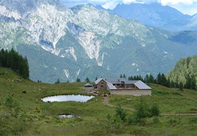
The malga was recently restructured, while retaining its original architectonic characteristics. Nearby, you can visit Lake Malins and observe the many newts that inhabit its waters. This picturesque Alpine landscape is particularly suggestive, due to a gorgeous view of the Pesarine Dolomites. By proceeding left from the shelter, you can reach malga Vinadia Grande and then descend towards the Pesarine Valley.
Lying at a comparably low altitude, its pastures are grazed between mid-May and mid-October. The grassy saddle of Navas (1,025 m) overlooks the Degano valley, northward, and is dominated by the calcareous massifs of the Monti di Volaia and by the Monte Coglians to the north, while you can admire the plateau of Lauco and its hamlets to the south-east.
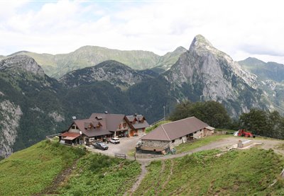
The structure was built near the peak of the homonymous mountain, in a location characterized by its suggestive beauty. This splendid panoramic position makes it a spectacular observation point looking onto nearby Alpine peaks such as the Çuc dal Bôr, Mount Cavallo, the Montasio Jôf and the Mangart. The area is inhabited by deer, roe deer and corncrakes.
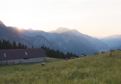
The main door of this malga features carvings and engraved initials that reveal the artistic skills and passions of the many malghesi and shepherds who lived here over the course of time. The malga is open in the intermediate grazing period, while its activities move to malga Ielma di Sotto during the initial and final pasturing phases. Similarly to a few other shelters in the region, the traditional boiler for milk processing, known as the “musse”, has been conserved in Upper Ielma. Above the basin where the malga is located, the slopes of the San Pietro Hill are peppered with larches, spruce trees and a few specimens of beech trees, while many raspberries can be found in the undergrowth. This malga offers a spectacular view of the Pesarine Dolomites. By crossing the pass from Upper Ielma you can descend towards the Pieltinis shelter and then to the Sauris basin (CAI trail n. 218).
Similarly to a few other shelters in the region, the traditional boiler for milk processing, known as the “musse”, has been conserved in Lower Ielma. The first documents referring to this malga date back to as early as the thirteenth century. Above the basin where the malga is located, the slopes of the San Pietro Hill are peppered with larches, spruce trees and a few specimens of beech trees, while many raspberries can be found in the undergrowth. The malga is open during the first and last weeks of pasture, while activities move to malga Ielma di Sotto during the intermediate period. By proceeding leftwards from the crossroads - located shortly after the shelter - visitors can reach San Giacomo; by proceeding straight ahead from here, you can climb a few short hairpin bends towards the nearby Ielma di Sopra shelter and then towards malga Pieltinis.
Above the pastures of malga Meleit is the peak of Mount Dauda (1.765 m a.s.l.), offering a majestic view on the valleys below. In order to reach the peak, you should proceed eastwards and, when the path starts its descent, take the trail on the right which traverses the ruins of the Chiâs di Sopra shelter and leads to the southern ridge of the mountain. From here, follow the crest leftwards to reach the peak. From the shelter, visitors can also reach Villa Santina or Zuglio. To get to the former, descend rightwards to reach Val di Lauco, Vinaio and Lauco; to reach the latter, proceed to the left until you get to malga Dauda, the Fielis hamlet and finally Zuglio.
The abundance of green alders makes this malga an ideal environment for goat grazing. A particularly interesting plant one may encounter in this area is the Rhodothamnus chamaecistus. By walking downwards from the Valuta shelter you will leave the detour towards Monteriù to your left and lose altitude until you encounter the confluence between the torrents Novarza and Pieltinis; from here, you can climb back upwards towards the path that connects Lateis di Sauris to the malghe of the district.
On the first Sunday of August, mass is held for the Alpine troops in the chapel next to the Malga, in memory of the discovery of the Redeemer during the Great War: the chapel was built by Alpine troops specifically to protect this finding. The pasture is called Pizzul because the Malga was split in two parts and this word means “Small” in the Friuli dialect. From the shelter, visitors can climb towards the Pizzul pass and descend from there directly to Cason di Lanza (CAI trails n. 441, 442, 442A). If on the other hand they choose to follow the dirt road, this will lead them to the nearby malga Paluchian (CAI n. 441B). The first historical document to reference the area indicates that animal grazing took place in malga Pizzul as early as the summer of 1295.
The dairy hut, also known as "Paronuzzi" is the most important alpine farm of the Cansiglio-Cavallo hogback. Located near the Piancavallo tourist resort, this farm is the only old high-altitude production units on the plateau that is still in operation.
This pasture plays an important role for the grazing sector due to its majestic nature. Near the malga is the usually dry riverbed of a branch of the Rio Losa, where you can observe alpenroses, hairy alpenroses, specimens of erica carnea or spring gentian. By proceeding on CAI trail n. 220 you can reach malga Forchia and descend towards Ovaro; above the Forchia shelter, visitors will find the start of the path leading up Col Gentile to an altitude of 2.075 m a.s.l. (CAI trail n. 235).
The pasturing area - which consists of various environments, the grazing space, the buildings, the wood and the waterholes - is frequented by numerous bird species, such as black redstarts and yellowhammers that find ideal feeding and nesting conditions in this area. However, the large amount of small birds also attracts their most deadly predator, the Eurasian sparrowhawk. By proceeding beyond the shelter, you will reach malga Pieltinis and the homonymous mountain (CAI trail n. 206).
The entire mountain range extending between Mount Rivo to the West and the peak of the Tersadia to the East is located in a central and isolated position from the Carnic area. These peaks offer breathtaking 360° views: from the High Tauern to the North all the way to the Adriatic Sea to the South, from the Dolomites located to the West to the highest peaks of the Julian Alps to the East. This ridge was used as a defensive system in the front line area during the Great War. Immediately under the peak are noteworthy remains of fortifications, walkways, trenches, tunnels and barracks. The malga complex known as the “Valmedan-Cucco” is located on the southern side of Mount Tersadia; from here, we highly recommend the excursion towards the suggestive peak of Mount Tersadia, at an altitude of 1.959 m a.s.l. (CAI trail n. 409), and the descent to Treppo Carnico in the Pontaiba Valley. From malga Valmedan Alta, you can also reach the Cucco shelter (on CAI trail n. 409) and then climb towards the homonymous peak at an altitude of 1.804 m (CAI trail n. 408°).
The 360° degree view allows observers to admire the Adriatic Sea, Mount Lussari and the Grosslockner. The nearby Mount Tenchia is the location of the "witches plateau", shrouded in legends concerning secret meetings between local and Nordic witches. This local myth inspired the poem "In Carnia" by Giosuè Carducci. Outcrops of effusive volcanic rocks can be found in the small lakes of Zoufplan. Here, the local Civil Protection has built a building to house a weather radar and tools for detecting seismic movements. From the malga, you can climb to Mount Tenchia, to the Zoufplan lakes and to the panoramic Cimon di Crasulina; from here, you can follow CAI trail n. 154 along the entire Tarondon – Pezzacucco – Crostis ridge.
Also known as the "Schenewelde" farmhouse, the structure rises nearby the homonymous pass, in a small panoramic valley surrounded by an unspoiled natural environment. A particularly noteworthy landmark is the "Tiziana Weiss Naturalistic Trail", one of the first self-guided trails of the Region.
This entirely restructured shelter has retained its ancient architecture thanks to a meticulous recovery of the ancient stones that made up the original walls of the building. After returning to malga Ielma di Sotto, you can proceed leftwards towards the Jelma pass and descend towards the Pieltinis shelter and then to the Sauris basin (CAI trail n. 218).
This malga is located on the North-West flank of Col Gentile, and from the peak of this mountain you can enjoy a magnificent view of the green Losa, Navarza and Torondon mountain range, of the glacial valleys that cross its southern flank and of the Creta Forata on the background. By climbing northwards, visitors can reach the Malins and Festons malghe and descend towards Upper Sauris (CAI trail n. 204); if they choose to proceed southwards, CAI trail n. 206 will lead to the Pieltinis and Gerona malghe and then descend towards Lateis di Sauris.
CAI trail n. 402, which connects Pramosio to Malpasso, features the memorial plaque dedicated to Maria Plozner Mentil, killed while carrying supplies to the frontline. Her story and that of all Carnic Bearers was progressively forgotten up until 1997, when the former President of the Italian Republic Scalfaro awarded these historical figures with the Gold Medal for Military Valour. From the Pramosio Pass you can visit numerous First World War sites and structures such as tunnels, trenches and posts. Malga Pramosio is the location of the only medieval mining tunnel in the eastern Alps, still intact in its original state. By proceeding beyond the shelter on CAI trail n. 402, you can reach the Malpasso ricovero Morgante shelter, the shelter of the Manze and, at an even higher altitude, the Upper Pramosio shelter with the splendid Lake Avostanis, surmounted by one of the most beautiful cliffs in the eastern Alpine range.
The pastures of malga Pieltinis cover the entire East flank of the homonymous mountain and the valley line beneath the peak features one of the richest heath areas in the whole Carnic Alps range. In addition to Alpine rhubarb, the meadows next to the malga also feature Alpine Timothy-grass, dandelions and specimens of Campanula scheuchzeri. From the Pieltinis shelter visitors can climb rightwards, traverse the Ielma pass and descend towards the Ielma di Sopra and Ielma di Sotto malghe before reaching the Pesarine Valley (CAI trail nThe pastures of malga Pieltinis cover the entire East flank of the homonymous mountain and the valley line beneath the peak features one of the richest heath areas in the whole Carnic Alps range. In addition to Alpine rhubarb, the meadows next to the malga also feature Alpine Timothy-grass, dandelions and specimens of Campanula scheuchzeri. From the Pieltinis shelter visitors can climb rightwards, traverse the Ielma pass and descend towards the Ielma di Sopra and Ielma di Sotto malghe before reaching the Pesarine Valley (CAI trail n. 218); turn leftwards from the lodges to traverse the Pieltinis pass and descend towards the Vinadia Grande malghe (CAI trail n. 204).. 218); turn leftwards from the lodges to traverse the Pieltinis pass and descend towards the Vinadia Grande malghe (CAI trail n. 204).
The green alder shrubs near Malga Vinadia Grande are an ideal habitat for black grouses. Climbing northwards visitors can reach the Malins and Festons malghe and form there they can descend towards Upper Sauris (CAI trail n. 204); by proceeding southwards, you will reach the Pieltinis and Gerona malghe and descend towards Lateis di Sauris (CAI trail n. 206).
From Paularo, you can follow indications for the Cason di Lanza pass and, after passing the Lower Ramaz Shelter, reach the Lower Meledis pastures in less than one kilometre. The malga is open during the first and last weeks of pasture, while activities move to malga Meledis Alta during the intermediate period. By proceeding along the road, visitors can climb to the Lower Valbertat shelter and, by turning left from here, reach malga Valbertat Alta. From here, they can enter the Austrian territory on CAI trail n. 449 and proceed to malga Straniger.
The Montasio plateau, a place of extraordinary beauty, is the largest grazing area in the entire region. The following malghe are all located in this district: Cregnedul di sopra, Larice, Parte di Mezzo and Pecol, dedicated to cheese production and agro-tourism. The history of the area describes the birth of Montasio cheese at the start of the thirteenth century, thanks to the Benedictine monks from Moggio Udinese. From a naturalistic point of view, in this area visitors can encounter rooster combs, broom flowers, marmots, deer, chamois, roe deer and foxes. From the Plains of the Montasio, you can return to Sella Nevea and descend towards Tarvisio via the town of Cave del Predil with its charming lake. Starting from the Pecol shelter, you can also easily reach the Giacomo Di Brazzà Refuge (on CAI trail n. 622), a splendid balcony looking onto the Mount Canin range.
The structure is open during the intermediate pasturing period, while its managers carry out their initial and final pasturing period activities in malga Ramaz instead. The structure is located on the southern slopes of Mount Lodin, characterized by Silurian rocks of marine origin that contain many invertebrate fossils, such as those of cephalopods with their characteristic shells. Corals are also frequently found in this area. The shelter is located on the “Carnic Crossing” and “Carnia Trekking” trails. From the malga, visitors can climb to the Lodinut pass (CAI trail n. 457), and by proceeding leftwards from there (CAI trail n. 403) they can reach Lake Zollner See in the Austrian territory, easily get to the Pecol di Chiaula pass and descend to the Pietro Fabiani refuge (CAI trail n. 454), therefore completing a circle and reuniting near the Upper Lodin shelter with the path that led them up the mountain.
During the war, this shelter was the logistics centre of the valley and it still features the remains of military shelters, as well as a cave known as the “Company of the Brigands”. A small church was built near the malga to commemorate the fallen soldiers from the Gemona Battalion. The farmhouse is the result of restructuring operations on the shelter that had been abandoned during the early 1950s, when traditional grazing activities no longer took place here: its recovery further valorises one of the many historical sites of the valley. From here, you can enjoy views of the Jôf del Montasio and the Julian Alps range. From a naturalistic point of view, in this area you will find: wild orchids, roe deer, chamois, deer and lynxes. From the malga, you can climb towards Sella Sompdogna, reach the homonymous malga and, from there, proceed even further towards the Grego Brothers Refuge.
The malga is open during the first and last weeks of pasture, while activities move to malga Lodin Alta during the intermediate period. The Stua di Ramaz is located nearby, East of the Chiarsò torrent. The site takes its name from the large barrier (“stua”= enclosure) once built to facilitate the transportation of timber towards the valley. On July 15th 1944, while exploring the north-eastern Carnia mountains, German soldiers killed some shepherds in Malga Cason di Lanza and Malga Confin e Meledis. A memorial stone featuring the writing “peace to the fallen ones – aid to themselves” was erected in 1946 to commemorate the victims from Lanza and Cordin, and can be found on the path leading from Paularo to Cason di Lanza via the Ramaz Shelter. From the shelter, visitors can reach the Cason di Lanza pass and either proceed on the road towards Pontebba or follow CAI trail n. 454 towards the Fabiani Refuge.
In 1478, on Plan di Lanze, a violent battle took place between the Turks – who were trying to cross the pass – and Venetian troops flanked by Carnic militias. The Turks were defeated and pushed back, and the Carnia area was therefore saved from their dreaded raids. According to legend the name, Plan di Lanze, derives from the lances abandoned on the battlefield by the defeated Turks. A didactic rocky gym has been built at a distance of just approximately one hundred metres from the shelter. This site offers a magnificent view of Mount Zermula and of the Creta di Aip. The shelter is the ideal starting point for many excursions, including climbs towards Mount Zermula (2.143 m) (CAI trails n. 442 and 442A), or towards the Lomasti bivouac, via malga Val Dolce and the Aip Valley (CAI trails n. 439 and 440).
From the start of the Mount Croce Carnico Pass terrace, proceed leftwards along a dirt road (CAI trail n. 161) to reach the nearby malga Collinetta di Sotto in just a few minutes. Along the way, you will encounter various inscriptions marking the “Via Julia Augusta” that once connected Aquileia to Noricum through the Mount Croce Carnico Pass. The Austrian flank near the pass is the location of the first recoveries of Great War posts for the outdoor history Museum that develops all the way to the peaks of the Pal Piccolo (1.866 m), Freikofel (1.757 m) and Pal Grande (1.809 m). From here, you can proceed westwards on CAI trail n. 148, leading to the road towards malga Val di Collina, malga Collina Grande, malga Plotta, the Monumenz shelter and the Marinelli refuge.
Starting from this pasture, which offers a fascinating view of the Dolomite range, visitors can reach the trail climbing from Cima Sappada towards the Source of the River Piave and the “Pier Fortunato Calvi” Refuge. The southern flank of Mount Avanza, which dominates this pasture, features ancient copper and silver mines still containing the remains of pestles used for the crushing of minerals. This area of noteworthy historical value can be reached by following CAI trail n. 173, starting from the hairpin bend located 100 m to the East of the shelter and climbing steeply towards a crossroads where visitors should follow CAI trail n. 177 to the right.
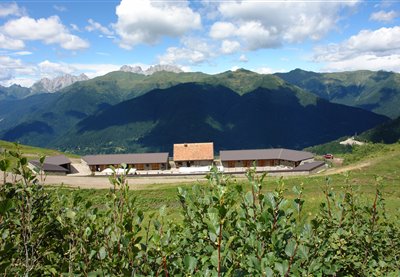
The structure rises on the southern-east side of Mount Punta Bella. From this panoramic point you can enjoy a view on the Valle del But, on Val Lauco, on Val Tagliamento to Prealpi Carniche and Marano lagoon. Its position is strategic in the hiking and cycling scene.
The malga is open during the intermediate pasturing period, while its managers carry out their initial and final pasturing period activities in malga Meledis Bassa. Visitors can observe Austrian trenches from the Great War on the Puartis Valley Peak, slightly above the shelter. On July 15th 1944, while exploring the north-eastern Carnia mountains, German soldiers killed a few shepherds on the Lanza and Cordin malga. These victims are celebrated by a memorial stone featuring the words “peace for the fallen ones – aid to themselves”, located on the path leading from Paularo to Cason di Lanza via the Ramaz Shelter. From the shelter, you can reach the Upper Lodin malghe (on Cai trail n. 448B), or choose to turn right and cross the Malinfier brook, reach the Meledis pass and descend towards malga Straniger, in Austria.
On the asphalt road from Paularo, follow indications towards the Cason di Lanza Pass and turn right in the “Baita da Nelut” area onto a very steep forest path (CAI trail n. 442) that climbs towards the Zermula shelter. Along the path from Paularo to the malghe, approximately one kilometre after the “Maina della Schialute”, visitors will find indications for a short trail leading to the “Palm”, a prodigious secular white fir tree listed among the main natural monuments of the Friuli Venezia Giulia region. Trenches dating back to the Great War can still be found nearby the malga. Proceed on the road built during the First World War to reach the peak of the panoramic Mount Zermula (2.143 m).
This malga was rebuilt after being destroyed by an avalanche during the 1980s. From the Moraretto shelter, visitors can follow a road or CAI trail n. 143 to the Giovanni Marinelli Refuge (2.111 m), built in 1901, and then descend along CAI trail n. 148 towards the Mount Croce Carnico pass. The pastures extending between the shelter and the Marinelli Refuge are home to a large colony of marmots. The hamlet of Collina in the Forni Avoltri area is particularly important for the regional dairy sector, given that the first local dairy production cooperative was founded here in 1881: the building still stands here with its ancient sign.
Dirt roads may include fairly bumpy stretches, especially after unfavourable weather; in particular, the descent from the Corce saddle to the ruins of the Dolaces farmhouses. In the densely-growing brushwood shrubs lives a nice, peculiar animal: the dormouse, a small rodent of the Gliridae family with a bizarre tail which is longer than its body and moderately prehensile. This allows it to move acrobatically around bushes.
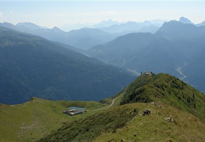
The structure is surrounded by an actual natural botanical garden, featuring great yellow gentian, wild gladiolus and carnations. The homonymous mountain appears as a grassy pyramid from which the viewer can observe the entire Friuli region. The top of the mountain houses the small Church of the Redeemer. Near the malga is the start of the downhill trail.
The panoramic view on the breathtaking naturalistic landscape you can enjoy from this malga covers the entire plain of the Friuli region and, on particularly clear days, the viewer’s gaze can travel all the way from the course of the Tagliamento River to the Adriatic Sea. Griffons are known to circle in the skies of this area, while the fields are inhabited by feral horses (Koniks).
The structure is located on a grazing saddle on the border of the Julian Prealps Natural Park, on the mid-southern flank of Mount Lavara. The shelter is surrounded by unspoiled nature, where walkers may encounter roe deer, chamois, ibex, marmots, eagles and many other animal species.
The Pancotto family has managed the malga, farm restaurant and didactic farm since 2011, offering children and kids the opportunity to spend a week discovering life in the pastures.
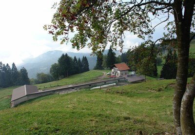
The Alpine farm is located inside a doline, a karstic depression called "fossa" in the local dialect. Under the new facilities the remains of the old buildings can still be discerned. The natural or man-made water pool is called "lama". The entire district is marked by these small hollows with impermeable bottoms where rain water and melting snow gather.
The Alpine farm is located in a small hollow at the feet of the Col Scarpat and also includes the pastures of the Bos and Busa Bravin farms, whose long abandoned facilities are no longer recognizable. The stony pastures characterize the farm, as does the juniper, a plant usually avoided by animals because of its stinging leaves. The location of these pastures offers a broad view over the whole Friulian Alps range.
The farmhouse is located in an old building which has retained all of its ancient charm, surrounded by hills and beech woods. The malga (mountain hut) is located in the southernmost part of the Cansiglio Forest, the second largest in Italy and one of the most important environmental resources of the entire region. The Patriarca trail passes in front of the malga.
This pasture is very rich both in terms of wildlife and from a naturalistic point of view, thanks to the presence of nettle, ferns, yarrow and mountain sage. The renovation of the buildings involved the historical recovery of the old shelter as a testimony of ancient life in the pastures.
The shelter can be reached by climbing the carriage road from Clau along the Val Cellina (CAI n.966). The malga is surrounded by a grassy plateau, characterized by alluvial deposits. Theropod footprints were discovered nearby, and are considered to be one of the most important pieces of evidence for proving the presence of dinosaurs in Italy.